Mikrókampos geodata
Mikrókampos (Central Macedonia) is a populated place; located in Greece in Europe/Athens (GMT+3) time zone. With population of 731 people, there are 1361 cities with bigger population in this country. Compared to other cities in Greece, 87.1% of cities are located further ↓South; 52.7% of cities are located further →East and 51.9% of cities have higher elevation than Mikrókampos. Note1


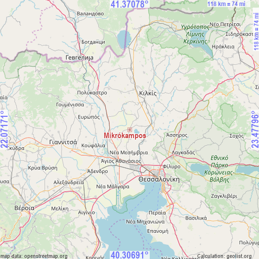
Mikrókampos GPS coordinates[2]
40° 50' 27.528" North, 22° 46' 29.388" East
| Map corner | latitude | longitude |
|---|---|---|
| Upper-left | 41.37078°, | 22.07171° |
| Center: | 40.84098°, | 22.77483° |
| Lower-right: | 40.30691°, | 23.47796° |
| Map W x H: | 118.3×118.3 km | = 73.5×73.5mi |
| max Lat: | 41.72048° ⇑12.9% North |
| Mikrókampos: | 40.84098° |
| min Lat: | ⇓87.1% South 34.8346° |
| min Long | Mikrókampos | max Long |
| 19.40494° | 22.77483° | 29.59361° |
| W 47.3%⇐ | ⇒52.7% E |
Elevation
Elevation of Mikrókampos is 74 m = 243 ft, and this is 94.9 m = 311 ft below average elevation for this country.
| Max E: |
1439 m = 4721 ft | 51.9% |
| Avg. | 168.9 m = 554 ft | |
| Mikrókampos | 74 m = 243 ft | |
Min E: |
0 m = 0 ft | 48.1% |
See also: Greece elevation on elevation.city.
Geographical zone
Mikrókampos is located in North temperate zone (between Tropic of Cancer and the Arctic Circle). Distance of this Northern Tropic circle is 1935.2 km =1202.5 mi to South.| Distance of | km | miles | from Mikrókampos |
|---|---|---|---|
| North Pole | 5466 | 3396.4 | to North |
| Arctic Circle | 2860.1 | 1777.2 | to North |
| Tropic Cancer | 1935.2 | 1202.5 | to South |
| Equator | 4541.1 | 2821.7 | to South |


Nearby cities:
15 places around Mikrókampos: (largest is in red/bold)
• Akropótamos
10.2 km =6.3 mi,  269°
269°
• Gallikós
8.7 km =5.4 mi,  77°
77°
• Kastanás
10.1 km =6.3 mi,  256°
256°
• Mavronéri
6.1 km =3.8 mi,  32°
32°
• Néa Filadélfeia
7.3 km =4.5 mi,  130°
130°
• Néa Mesimvría
10 km =6.2 mi,  182°
182°
• Néa Sánta
12.3 km =7.6 mi,  90°
90°
• Néo Agionéri
6.7 km =4.2 mi,  237°
237°
• Néo Gynaikókastro
9.3 km =5.8 mi,  345°
345°
• Palaió Agionéri
4.9 km =3 mi,  233°
233°
• Pedinó
11.3 km =7 mi,  46°
46°
• Pentálofos
12.7 km =7.9 mi,  149°
149°
• Próchoma
10.3 km =6.4 mi, 242°
• Vathýlakkos
9.7 km =6 mi,  214°
214°
• Xirochóri
4.2 km =2.6 mi, 175°
Sources, notices
• [Note1] Compared only with cities in Greece existing in our database
• [Src1] Map data: © OpenStreetMap contributors (CC-BY-SA)
• [Src2] Other city data from geonames.org with taken over terms of usage.
• [Src3] Geographical zone / Annual Mean Temperature by Robert A. Rohde @ Wikipedia
