Vathýlakkos geodata
Vathýlakkos (Central Macedonia) is a populated place; located in Greece in Europe/Athens (GMT+3) time zone. With population of 2,218 people, there are 464 cities with bigger population in this country. Compared to other cities in Greece, 84.1% of cities are located further ↓South; 54.9% of cities are located further →East and 55.8% of cities have lower elevation than Vathýlakkos. Note1
Administrative division(s):
- Level 1: Central Macedonia
- Level 2: Nomós Thessaloníkis
- Level 3: Dimos Chalkidona


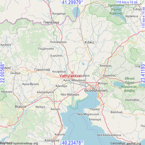
Vathýlakkos GPS coordinates[2]
40° 46' 9.912" North, 22° 42' 31.68" East
| Map corner | latitude | longitude |
|---|---|---|
| Upper-left | 41.29979°, | 22.00568° |
| Center: | 40.76942°, | 22.7088° |
| Lower-right: | 40.23478°, | 23.41193° |
| Map W x H: | 118.4×118.4 km | = 73.6×73.6mi |
| max Lat: | 41.72048° ⇑15.9% North |
| Vathýlakkos: | 40.76942° |
| min Lat: | ⇓84.1% South 34.8346° |
| min Long | Vathýlakkos | max Long |
| 19.40494° | 22.7088° | 29.59361° |
| W 45.1%⇐ | ⇒54.9% E |
Elevation
Elevation of Vathýlakkos is 101 m = 331 ft, and this is 67.9 m = 223 ft below average elevation for this country.
| Max E: |
1439 m = 4721 ft | 44.2% |
| Avg. | 168.9 m = 554 ft | |
| Vathýlakkos | 101 m = 331 ft | |
Min E: |
0 m = 0 ft | 55.8% |
See also: Greece elevation on elevation.city.
Geographical zone
Vathýlakkos is located in North temperate zone (between Tropic of Cancer and the Arctic Circle). Distance of this Northern Tropic circle is 1927.2 km =1197.5 mi to South.| Distance of | km | miles | from Vathýlakkos |
|---|---|---|---|
| North Pole | 5473.9 | 3401.3 | to North |
| Arctic Circle | 2868 | 1782.1 | to North |
| Tropic Cancer | 1927.2 | 1197.5 | to South |
| Equator | 4533.1 | 2816.7 | to South |


Nearby cities:
15 places around Vathýlakkos: (largest is in red/bold)
• Akropótamos
9.1 km =5.7 mi,  329°
329°
• Anchíalos
8.5 km =5.3 mi,  135°
135°
• Chalkidóna
10.1 km =6.3 mi,  245°
245°
• Eleoúsa
7.3 km =4.5 mi, 251°
• Géfyra
4.3 km =2.7 mi,  197°
197°
• Kastanás
7 km =4.3 mi,  322°
322°
• Mikrókampos
9.7 km =6 mi,  34°
34°
• Néa Filadélfeia
11.5 km =7.1 mi,  74°
74°
• Néa Mesimvría
5.4 km =3.4 mi,  111°
111°
• Néo Agionéri
4.3 km =2.7 mi,  358°
358°
• Palaió Agionéri
5.3 km =3.3 mi,  17°
17°
• Parthéni
11.5 km =7.1 mi,  228°
228°
• Próchoma
4.8 km =3 mi,  312°
312°
• Xirochóri
7 km =4.3 mi,  57°
57°
• Ágios Athanásios
6.2 km =3.9 mi,  164°
164°
Sources, notices
• [Note1] Compared only with cities in Greece existing in our database
• [Src1] Map data: © OpenStreetMap contributors (CC-BY-SA)
• [Src2] Other city data from geonames.org with taken over terms of usage.
• [Src3] Geographical zone / Annual Mean Temperature by Robert A. Rohde @ Wikipedia
