Gallikós geodata
Gallikós (Central Macedonia) is a populated place; located in Greece in Europe/Athens (GMT+3) time zone. With population of 969 people, there are 1053 cities with bigger population in this country. Compared to other cities in Greece, 87.5% of cities are located further ↓South; 51% of cities are located further ←West and 50.3% of cities have lower elevation than Gallikós. Note1


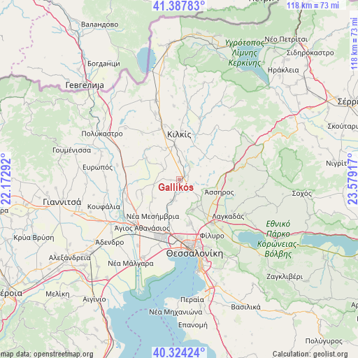
Gallikós GPS coordinates[2]
40° 51' 29.412" North, 22° 52' 33.744" East
| Map corner | latitude | longitude |
|---|---|---|
| Upper-left | 41.38783°, | 22.17292° |
| Center: | 40.85817°, | 22.87604° |
| Lower-right: | 40.32424°, | 23.57917° |
| Map W x H: | 118.3×118.3 km | = 73.5×73.5mi |
| max Lat: | 41.72048° ⇑12.5% North |
| Gallikós: | 40.85817° |
| min Lat: | ⇓87.5% South 34.8346° |
| min Long | Gallikós | max Long |
| 19.40494° | 22.87604° | 29.59361° |
| W 51%⇐ | ⇒49% E |
Elevation
Elevation of Gallikós is 82 m = 269 ft, and this is 86.9 m = 285 ft below average elevation for this country.
| Max E: |
1439 m = 4721 ft | 49.7% |
| Avg. | 168.9 m = 554 ft | |
| Gallikós | 82 m = 269 ft | |
Min E: |
0 m = 0 ft | 50.3% |
See also: Greece elevation on elevation.city.
Geographical zone
Gallikós is located in North temperate zone (between Tropic of Cancer and the Arctic Circle). Distance of this Northern Tropic circle is 1937.1 km =1203.7 mi to South.| Distance of | km | miles | from Gallikós |
|---|---|---|---|
| North Pole | 5464.1 | 3395.2 | to North |
| Arctic Circle | 2858.2 | 1776 | to North |
| Tropic Cancer | 1937.1 | 1203.7 | to South |
| Equator | 4543 | 2822.9 | to South |


Nearby cities:
15 places around Gallikós: (largest is in red/bold)
• Drymós
11.1 km =6.9 mi,  140°
140°
• Kampánis
4.9 km =3 mi,  44°
44°
• Kristóni
11.4 km =7.1 mi,  352°
352°
• Krithiá
9.2 km =5.7 mi,  101°
101°
• Mavronéri
6.2 km =3.9 mi,  301°
301°
• Melissochóri
11 km =6.8 mi,  156°
156°
• Mikrókampos
8.7 km =5.4 mi,  257°
257°
• Neochoroúda
13.3 km =8.3 mi,  180°
180°
• Néa Filadélfeia
7.3 km =4.5 mi,  204°
204°
• Néa Sánta
4.3 km =2.7 mi,  116°
116°
• Néo Gynaikókastro
13 km =8.1 mi, 302°
• Palaió Agionéri
13.4 km =8.3 mi,  248°
248°
• Pedinó
5.8 km =3.6 mi,  357°
357°
• Pentálofos
13 km =8.1 mi,  188°
188°
• Xirochóri
10.2 km =6.3 mi,  233°
233°
Sources, notices
• [Note1] Compared only with cities in Greece existing in our database
• [Src1] Map data: © OpenStreetMap contributors (CC-BY-SA)
• [Src2] Other city data from geonames.org with taken over terms of usage.
• [Src3] Geographical zone / Annual Mean Temperature by Robert A. Rohde @ Wikipedia
