Metamórfosi geodata
Metamórfosi (Central Macedonia) is a populated place; located in Greece in Europe/Athens (GMT+3) time zone. With population of 531 people, there are 1737 cities with bigger population in this country. Compared to other cities in Greece, 68.8% of cities are located further ↓South; 66.8% of cities are located further ←West and 74.9% of cities have higher elevation than Metamórfosi. Note1
Administrative division(s):
- Level 1: Central Macedonia
- Level 2: Nomós Chalkidikís
- Level 3: Dimos Polygyros


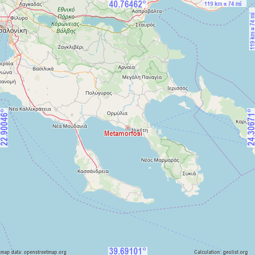
Metamórfosi GPS coordinates[2]
40° 13' 47.784" North, 23° 36' 12.888" East
| Map corner | latitude | longitude |
|---|---|---|
| Upper-left | 40.76462°, | 22.90046° |
| Center: | 40.22994°, | 23.60358° |
| Lower-right: | 39.69101°, | 24.30671° |
| Map W x H: | 119.4×119.4 km | = 74.2×74.2mi |
| max Lat: | 41.72048° ⇑31.2% North |
| Metamórfosi: | 40.22994° |
| min Lat: | ⇓68.8% South 34.8346° |
| min Long | Metamórfosi | max Long |
| 19.40494° | 23.60358° | 29.59361° |
| W 66.8%⇐ | ⇒33.2% E |
Elevation
Elevation of Metamórfosi is 24 m = 79 ft, and this is 144.9 m = 475 ft below average elevation for this country.
| Max E: |
1439 m = 4721 ft | 74.9% |
| Avg. | 168.9 m = 554 ft | |
| Metamórfosi | 24 m = 79 ft | |
Min E: |
0 m = 0 ft | 25.1% |
See also: Greece elevation on elevation.city.
Geographical zone
Metamórfosi is located in North temperate zone (between Tropic of Cancer and the Arctic Circle). Distance of this Northern Tropic circle is 1867.2 km =1160.2 mi to South.| Distance of | km | miles | from Metamórfosi |
|---|---|---|---|
| North Pole | 5533.9 | 3438.6 | to North |
| Arctic Circle | 2928 | 1819.4 | to North |
| Tropic Cancer | 1867.2 | 1160.2 | to South |
| Equator | 4473.2 | 2779.5 | to South |


Nearby cities:
15 places around Metamórfosi: (largest is in red/bold)
• Kallithéa
21.9 km =13.6 mi,  217°
217°
• Kalýves Polygýrou
19.2 km =11.9 mi,  289°
289°
• Metagkítsi
11.4 km =7.1 mi,  22°
22°
• Néa Fókaia
20.5 km =12.7 mi,  238°
238°
• Néa Potídhaia
23.7 km =14.7 mi,  260°
260°
• Néos Marmarás
21.3 km =13.2 mi,  134°
134°
• Níkiti
5.6 km =3.5 mi,  99°
99°
• Ormýlia
8.8 km =5.5 mi,  324°
324°
• Polýgyros
21.4 km =13.3 mi, 319°
• Taxiárchis
22.7 km =14.1 mi,  342°
342°
• Vrástama
16.8 km =10.4 mi, 340°
• Áfytos
20.3 km =12.6 mi, 224°
• Ágios Mámas
23 km =14.3 mi,  278°
278°
• Ágios Nikólaos
8.1 km =5 mi,  74°
74°
• Ólynthos
23.2 km =14.4 mi, 287°
Sources, notices
• [Note1] Compared only with cities in Greece existing in our database
• [Src1] Map data: © OpenStreetMap contributors (CC-BY-SA)
• [Src2] Other city data from geonames.org with taken over terms of usage.
• [Src3] Geographical zone / Annual Mean Temperature by Robert A. Rohde @ Wikipedia
