Polýgyros geodata
Polýgyros (Central Macedonia) is a seat of a second-order administrative division; located in Greece in Europe/Athens (GMT+3) time zone. With population of 10,000 people, there are 141 cities with bigger population in this country. Compared to other cities in Greece, 71.6% of cities are located further ↓South; 63.3% of cities are located further ←West and 90.9% of cities have lower elevation than Polýgyros. Note1
Administrative division(s):
- Level 1: Central Macedonia
- Level 2: Nomós Chalkidikís
- Level 3: Dimos Polygyros


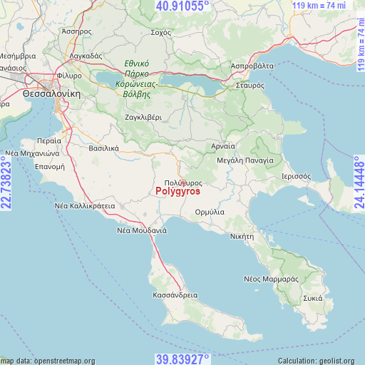
Polýgyros GPS coordinates[2]
40° 22' 37.344" North, 23° 26' 28.86" East
| Map corner | latitude | longitude |
|---|---|---|
| Upper-left | 40.91055°, | 22.73823° |
| Center: | 40.37704°, | 23.44135° |
| Lower-right: | 39.83927°, | 24.14448° |
| Map W x H: | 119.1×119.1 km | = 74×74mi |
| max Lat: | 41.72048° ⇑28.4% North |
| Polýgyros: | 40.37704° |
| min Lat: | ⇓71.6% South 34.8346° |
| min Long | Polýgyros | max Long |
| 19.40494° | 23.44135° | 29.59361° |
| W 63.3%⇐ | ⇒36.7% E |
Elevation
Elevation of Polýgyros is 523 m = 1716 ft, and this is 354.1 m = 1162 ft above average elevation for this country.
| Max E: |
1439 m = 4721 ft | 9.1% |
| Polýgyros | 523 m 1716 ft | |
| Avg. | 168.9 m = 554 ft | |
Min E: |
0 m = 0 ft | 90.9% |
See also: Greece elevation on elevation.city.
Geographical zone
Polýgyros is located in North temperate zone (between Tropic of Cancer and the Arctic Circle). Distance of this Northern Tropic circle is 1883.6 km =1170.4 mi to South.| Distance of | km | miles | from Polýgyros |
|---|---|---|---|
| North Pole | 5517.6 | 3428.5 | to North |
| Arctic Circle | 2911.7 | 1809.2 | to North |
| Tropic Cancer | 1883.6 | 1170.4 | to South |
| Equator | 4489.5 | 2789.6 | to South |


Nearby cities:
15 places around Polýgyros: (largest is in red/bold)
• Arnaía
17.8 km =11.1 mi,  46°
46°
• Galátista
17 km =10.6 mi,  306°
306°
• Kalamotó
20.7 km =12.9 mi,  343°
343°
• Kalýves Polygýrou
10.9 km =6.8 mi,  203°
203°
• Metagkítsi
19 km =11.8 mi,  107°
107°
• Metamórfosi
21.4 km =13.3 mi,  139°
139°
• Néa Moudhaniá
19.9 km =12.4 mi,  221°
221°
• Ormýlia
12.6 km =7.8 mi, 136°
• Palaiochóra
13.8 km =8.6 mi,  3°
3°
• Portariá
16.1 km =10 mi,  230°
230°
• Símantra
11.6 km =7.2 mi,  252°
252°
• Taxiárchis
8.7 km =5.4 mi, 52°
• Vrástama
8 km =5 mi,  94°
94°
• Ágios Mámas
15.9 km =9.9 mi,  214°
214°
• Ólynthos
12.7 km =7.9 mi, 221°
In other languages:
- In Spanish: Polígiros
- In France: Polygyros
- In German: Polygyros
- In Italian: Polygyros
- In Russian: Полийирос
- In Chinese: 波利伊罗斯
Sources, notices
• [Note1] Compared only with cities in Greece existing in our database
• [Src1] Map data: © OpenStreetMap contributors (CC-BY-SA)
• [Src2] Other city data from geonames.org with taken over terms of usage.
• [Src3] Geographical zone / Annual Mean Temperature by Robert A. Rohde @ Wikipedia
