Metagkítsi geodata
Metagkítsi (Central Macedonia) is a populated place; located in Greece in Europe/Athens (GMT+3) time zone. With population of 802 people, there are 1272 cities with bigger population in this country. Compared to other cities in Greece, 70.7% of cities are located further ↓South; 68.4% of cities are located further ←West and 65% of cities have lower elevation than Metagkítsi. Note1
Administrative division(s):
- Level 1: Central Macedonia
- Level 2: Nomós Chalkidikís
- Level 3: Dimos Sithonia


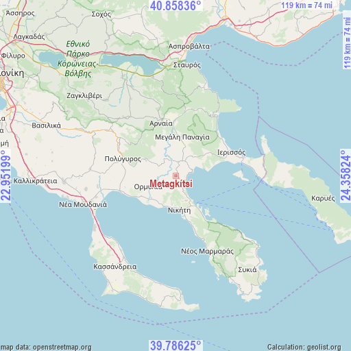
Metagkítsi GPS coordinates[2]
40° 19' 27.948" North, 23° 39' 18.396" East
| Map corner | latitude | longitude |
|---|---|---|
| Upper-left | 40.85836°, | 22.95199° |
| Center: | 40.32443°, | 23.65511° |
| Lower-right: | 39.78625°, | 24.35824° |
| Map W x H: | 119.2×119.2 km | = 74.1×74.1mi |
| max Lat: | 41.72048° ⇑29.3% North |
| Metagkítsi: | 40.32443° |
| min Lat: | ⇓70.7% South 34.8346° |
| min Long | Metagkítsi | max Long |
| 19.40494° | 23.65511° | 29.59361° |
| W 68.4%⇐ | ⇒31.6% E |
Elevation
Elevation of Metagkítsi is 140 m = 459 ft, and this is 28.9 m = 95 ft below average elevation for this country.
| Max E: |
1439 m = 4721 ft | 35% |
| Avg. | 168.9 m = 554 ft | |
| Metagkítsi | 140 m = 459 ft | |
Min E: |
0 m = 0 ft | 65% |
See also: Greece elevation on elevation.city.
Geographical zone
Metagkítsi is located in North temperate zone (between Tropic of Cancer and the Arctic Circle). Distance of this Northern Tropic circle is 1877.7 km =1166.7 mi to South.| Distance of | km | miles | from Metagkítsi |
|---|---|---|---|
| North Pole | 5523.4 | 3432.1 | to North |
| Arctic Circle | 2917.5 | 1812.8 | to North |
| Tropic Cancer | 1877.7 | 1166.7 | to South |
| Equator | 4483.7 | 2786 | to South |


Nearby cities:
15 places around Metagkítsi: (largest is in red/bold)
• Ammoulianí
22.6 km =14 mi,  87°
87°
• Arnaía
18.7 km =11.6 mi,  344°
344°
• Gomáti
14.3 km =8.9 mi,  56°
56°
• Ierissós
20.3 km =12.6 mi,  66°
66°
• Kalýves Polygýrou
22.8 km =14.2 mi,  259°
259°
• Megáli Panagía
13.6 km =8.5 mi,  8°
8°
• Metamórfosi
11.4 km =7.1 mi,  202°
202°
• Neochóri
20.6 km =12.8 mi, 5°
• Níkiti
11.4 km =7.1 mi,  174°
174°
• Ormýlia
10 km =6.2 mi,  250°
250°
• Palaiochóri
18.6 km =11.6 mi,  358°
358°
• Polýgyros
19 km =11.8 mi,  287°
287°
• Taxiárchis
15.9 km =9.9 mi,  314°
314°
• Vrástama
11.4 km =7.1 mi,  297°
297°
• Ágios Nikólaos
9.1 km =5.7 mi,  157°
157°
Sources, notices
• [Note1] Compared only with cities in Greece existing in our database
• [Src1] Map data: © OpenStreetMap contributors (CC-BY-SA)
• [Src2] Other city data from geonames.org with taken over terms of usage.
• [Src3] Geographical zone / Annual Mean Temperature by Robert A. Rohde @ Wikipedia
