Arsénio geodata
Arsénio (Central Macedonia) is a populated place; located in Greece in Europe/Athens (GMT+3) time zone. With population of 1,389 people, there are 728 cities with bigger population in this country. Compared to other cities in Greece, 81.8% of cities are located further ↓South; 68.3% of cities are located further →East and 63.2% of cities have higher elevation than Arsénio. Note1


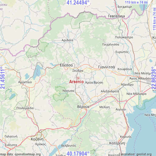
Arsénio GPS coordinates[2]
40° 42' 50.832" North, 22° 9' 33.228" East
| Map corner | latitude | longitude |
|---|---|---|
| Upper-left | 41.24494°, | 21.45611° |
| Center: | 40.71412°, | 22.15923° |
| Lower-right: | 40.17904°, | 22.86236° |
| Map W x H: | 118.5×118.5 km | = 73.6×73.6mi |
| max Lat: | 41.72048° ⇑18.2% North |
| Arsénio: | 40.71412° |
| min Lat: | ⇓81.8% South 34.8346° |
| min Long | Arsénio | max Long |
| 19.40494° | 22.15923° | 29.59361° |
| W 31.7%⇐ | ⇒68.3% E |
Elevation
Elevation of Arsénio is 43 m = 141 ft, and this is 125.9 m = 413 ft below average elevation for this country.
| Max E: |
1439 m = 4721 ft | 63.2% |
| Avg. | 168.9 m = 554 ft | |
| Arsénio | 43 m = 141 ft | |
Min E: |
0 m = 0 ft | 36.8% |
See also: Greece elevation on elevation.city.
Geographical zone
Arsénio is located in North temperate zone (between Tropic of Cancer and the Arctic Circle). Distance of this Northern Tropic circle is 1921.1 km =1193.7 mi to South.| Distance of | km | miles | from Arsénio |
|---|---|---|---|
| North Pole | 5480.1 | 3405.2 | to North |
| Arctic Circle | 2874.2 | 1785.9 | to North |
| Tropic Cancer | 1921.1 | 1193.7 | to South |
| Equator | 4527 | 2812.9 | to South |


Nearby cities:
15 places around Arsénio: (largest is in red/bold)
• Angelochóri
5.2 km =3.2 mi,  139°
139°
• Charíessa
7 km =4.3 mi,  174°
174°
• Eirinoúpoli
4.9 km =3 mi, 144°
• Episkopí
3.5 km =2.2 mi,  213°
213°
• Kalývia
6.7 km =4.2 mi,  47°
47°
• Káto Lipochóri
5.1 km =3.2 mi,  19°
19°
• Lefkádia
7.6 km =4.7 mi, 206°
• Marína
5.5 km =3.4 mi,  243°
243°
• Petraía
1.4 km =0.9 mi,  298°
298°
• Polyplátanos
4.4 km =2.7 mi, 142°
• Rizó
2.9 km =1.8 mi,  318°
318°
• Sevastianá
6.8 km =4.2 mi,  333°
333°
• Skýdra
5.9 km =3.7 mi,  354°
354°
• Stavrodrómi
4.9 km =3 mi,  93°
93°
• Áspro
5.3 km =3.3 mi,  63°
63°
Sources, notices
• [Note1] Compared only with cities in Greece existing in our database
• [Src1] Map data: © OpenStreetMap contributors (CC-BY-SA)
• [Src2] Other city data from geonames.org with taken over terms of usage.
• [Src3] Geographical zone / Annual Mean Temperature by Robert A. Rohde @ Wikipedia
