Lagkadás geodata
Lagkadás (Central Macedonia) is a populated place; located in Greece in Europe/Athens (GMT+3) time zone. With population of 7,215 people, there are 176 cities with bigger population in this country. Compared to other cities in Greece, 83.1% of cities are located further ↓South; 56.6% of cities are located further ←West and 56.5% of cities have lower elevation than Lagkadás. Note1
Administrative division(s):
- Level 1: Central Macedonia
- Level 2: Nomós Thessaloníkis
- Level 3: Dimos Lagkadas


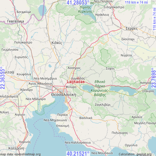
Lagkadás GPS coordinates[2]
40° 45' 0" North, 23° 4' 0.012" East
| Map corner | latitude | longitude |
|---|---|---|
| Upper-left | 41.28053°, | 22.36355° |
| Center: | 40.75°, | 23.06667° |
| Lower-right: | 40.21521°, | 23.7698° |
| Map W x H: | 118.5×118.5 km | = 73.6×73.6mi |
| max Lat: | 41.72048° ⇑16.9% North |
| Lagkadás: | 40.75° |
| min Lat: | ⇓83.1% South 34.8346° |
| min Long | Lagkadás | max Long |
| 19.40494° | 23.06667° | 29.59361° |
| W 56.6%⇐ | ⇒43.4% E |
Elevation
Elevation of Lagkadás is 103 m = 338 ft, and this is 65.9 m = 216 ft below average elevation for this country.
| Max E: |
1439 m = 4721 ft | 43.5% |
| Avg. | 168.9 m = 554 ft | |
| Lagkadás | 103 m = 338 ft | |
Min E: |
0 m = 0 ft | 56.5% |
See also: Greece elevation on elevation.city.
Geographical zone
Lagkadás is located in North temperate zone (between Tropic of Cancer and the Arctic Circle). Distance of this Northern Tropic circle is 1925.1 km =1196.2 mi to South.| Distance of | km | miles | from Lagkadás |
|---|---|---|---|
| North Pole | 5476.1 | 3402.7 | to North |
| Arctic Circle | 2870.2 | 1783.5 | to North |
| Tropic Cancer | 1925.1 | 1196.2 | to South |
| Equator | 4531 | 2815.4 | to South |


Nearby cities:
15 places around Lagkadás: (largest is in red/bold)
• Asvestochóri
12.6 km =7.8 mi,  196°
196°
• Drymós
9.7 km =6 mi,  290°
290°
• Efkarpía
11.8 km =7.3 mi,  234°
234°
• Fíliro
8.3 km =5.2 mi,  218°
218°
• Iráklion
2.7 km =1.7 mi, 286°
• Kavallári
4.2 km =2.6 mi, 204°
• Kolchikón
5.7 km =3.5 mi,  82°
82°
• Krithiá
12.4 km =7.7 mi,  325°
325°
• Lagyná
6 km =3.7 mi,  240°
240°
• Lití
7.3 km =4.5 mi,  265°
265°
• Melissochóri
11.8 km =7.3 mi,  279°
279°
• Perivolákion
2.7 km =1.7 mi,  256°
256°
• Péfka
11.9 km =7.4 mi,  211°
211°
• Ágios Vasíleios
10.3 km =6.4 mi,  157°
157°
• Ássiros
8.5 km =5.3 mi,  338°
338°
Sources, notices
• [Note1] Compared only with cities in Greece existing in our database
• [Src1] Map data: © OpenStreetMap contributors (CC-BY-SA)
• [Src2] Other city data from geonames.org with taken over terms of usage.
• [Src3] Geographical zone / Annual Mean Temperature by Robert A. Rohde @ Wikipedia
