Laimós geodata
Laimós (West Macedonia) is a seat of a third-order administrative division; located in Greece in Europe/Athens (GMT+3) time zone. With population of 185 people, there are 1817 cities with bigger population in this country. Compared to other cities in Greece, 86.7% of cities are located further ↓South; 88.6% of cities are located further →East and 98.8% of cities have lower elevation than Laimós. Note1


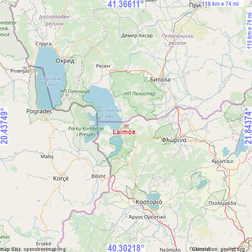
Laimós GPS coordinates[2]
40° 50' 10.608" North, 21° 8' 26.196" East
| Map corner | latitude | longitude |
|---|---|---|
| Upper-left | 41.36611°, | 20.43749° |
| Center: | 40.83628°, | 21.14061° |
| Lower-right: | 40.30218°, | 21.84374° |
| Map W x H: | 118.3×118.3 km | = 73.5×73.5mi |
| max Lat: | 41.72048° ⇑13.3% North |
| Laimós: | 40.83628° |
| min Lat: | ⇓86.7% South 34.8346° |
| min Long | Laimós | max Long |
| 19.40494° | 21.14061° | 29.59361° |
| W 11.4%⇐ | ⇒88.6% E |
Elevation
Elevation of Laimós is 910 m = 2986 ft, and this is 741.1 m = 2431 ft above average elevation for this country.
| Max E: |
1439 m = 4721 ft | 1.2% |
| Laimós | 910 m 2986 ft | |
| Avg. | 168.9 m = 554 ft | |
Min E: |
0 m = 0 ft | 98.8% |
See also: Greece elevation on elevation.city.
Geographical zone
Laimós is located in North temperate zone (between Tropic of Cancer and the Arctic Circle). Distance of this Northern Tropic circle is 1934.6 km =1202.1 mi to South.| Distance of | km | miles | from Laimós |
|---|---|---|---|
| North Pole | 5466.5 | 3396.7 | to North |
| Arctic Circle | 2860.6 | 1777.5 | to North |
| Tropic Cancer | 1934.6 | 1202.1 | to South |
| Equator | 4540.6 | 2821.4 | to South |


Nearby cities:
15 places around Laimós: (largest is in red/bold)
• Ammochóri
29.6 km =18.4 mi,  101°
101°
• Armenokhórion
27.2 km =16.9 mi, 97°
• Chlói
34.5 km =21.4 mi,  163°
163°
• Flórina
23.4 km =14.5 mi, 104°
• Itéa
31.4 km =19.5 mi,  90°
90°
• Kastoria
36.5 km =22.7 mi, 163°
• Kolokynthoú
37.3 km =23.2 mi,  170°
170°
• Melíti
37.3 km =23.2 mi, 90°
• Mesopotamía
37.2 km =23.1 mi,  177°
177°
• Néa Léfki
37.6 km =23.4 mi, 166°
• Pappagiánnis
30.1 km =18.7 mi, 89°
• Polykárpi
38.2 km =23.7 mi, 156°
• Sitariá
34.2 km =21.3 mi, 98°
• Skopiá
24.1 km =15 mi,  109°
109°
• Toichío
31.3 km =19.4 mi,  153°
153°
Sources, notices
• [Note1] Compared only with cities in Greece existing in our database
• [Src1] Map data: © OpenStreetMap contributors (CC-BY-SA)
• [Src2] Other city data from geonames.org with taken over terms of usage.
• [Src3] Geographical zone / Annual Mean Temperature by Robert A. Rohde @ Wikipedia
