Kryonéri geodata
Kryonéri (Central Macedonia) is a populated place; located in Greece in Europe/Athens (GMT+3) time zone. With population of 928 people, there are 1093 cities with bigger population in this country. Compared to other cities in Greece, 86% of cities are located further ↓South; 59.9% of cities are located further ←West and 92.9% of cities have lower elevation than Kryonéri. Note1
Administrative division(s):
- Level 1: Central Macedonia
- Level 2: Nomós Thessaloníkis
- Level 3: Dimos Lagkadas


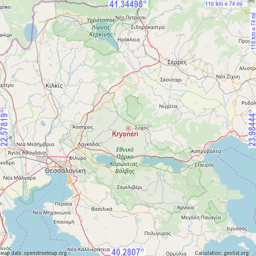
Kryonéri GPS coordinates[2]
40° 48' 53.892" North, 23° 16' 52.716" East
| Map corner | latitude | longitude |
|---|---|---|
| Upper-left | 41.34498°, | 22.57819° |
| Center: | 40.81497°, | 23.28131° |
| Lower-right: | 40.2807°, | 23.98444° |
| Map W x H: | 118.3×118.3 km | = 73.5×73.5mi |
| max Lat: | 41.72048° ⇑14% North |
| Kryonéri: | 40.81497° |
| min Lat: | ⇓86% South 34.8346° |
| min Long | Kryonéri | max Long |
| 19.40494° | 23.28131° | 29.59361° |
| W 59.9%⇐ | ⇒40.1% E |
Elevation
Elevation of Kryonéri is 605 m = 1985 ft, and this is 436.1 m = 1431 ft above average elevation for this country.
| Max E: |
1439 m = 4721 ft | 7.1% |
| Kryonéri | 605 m 1985 ft | |
| Avg. | 168.9 m = 554 ft | |
Min E: |
0 m = 0 ft | 92.9% |
See also: Greece elevation on elevation.city.
Geographical zone
Kryonéri is located in North temperate zone (between Tropic of Cancer and the Arctic Circle). Distance of this Northern Tropic circle is 1932.3 km =1200.7 mi to South.| Distance of | km | miles | from Kryonéri |
|---|---|---|---|
| North Pole | 5468.9 | 3398.2 | to North |
| Arctic Circle | 2863 | 1779 | to North |
| Tropic Cancer | 1932.3 | 1200.7 | to South |
| Equator | 4538.2 | 2819.9 | to South |


Nearby cities:
15 places around Kryonéri: (largest is in red/bold)
• Agía Paraskeví
21 km =13 mi,  44°
44°
• Askós
11.4 km =7.1 mi,  128°
128°
• Kolchikón
14 km =8.7 mi,  242°
242°
• Lagkadikia
20.1 km =12.5 mi,  188°
188°
• Lagkadás
19.5 km =12.1 mi,  248°
248°
• Nigríta
20.9 km =13 mi,  61°
61°
• Nikomidinó
19.8 km =12.3 mi,  181°
181°
• Nikókleia
18 km =11.2 mi, 43°
• Profítis
14.2 km =8.8 mi, 181°
• Sochós
6.2 km =3.9 mi,  87°
87°
• Stívos
18.5 km =11.5 mi,  174°
174°
• Terpní
20.3 km =12.6 mi, 56°
• Triantafylliá
19.6 km =12.2 mi,  16°
16°
• Vérgi
18.3 km =11.4 mi,  32°
32°
• Xilópolis
15.1 km =9.4 mi,  325°
325°
Sources, notices
• [Note1] Compared only with cities in Greece existing in our database
• [Src1] Map data: © OpenStreetMap contributors (CC-BY-SA)
• [Src2] Other city data from geonames.org with taken over terms of usage.
• [Src3] Geographical zone / Annual Mean Temperature by Robert A. Rohde @ Wikipedia
