Gorgópi geodata
Gorgópi (Central Macedonia) is a populated place; located in Greece in Europe/Athens (GMT+3) time zone. With population of 872 people, there are 1169 cities with bigger population in this country. Compared to other cities in Greece, 90.7% of cities are located further ↓South; 59.6% of cities are located further →East and 54.8% of cities have higher elevation than Gorgópi. Note1


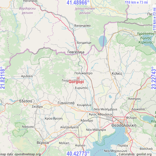
Gorgópi GPS coordinates[2]
40° 57' 38.988" North, 22° 31' 27.48" East
| Map corner | latitude | longitude |
|---|---|---|
| Upper-left | 41.48966°, | 21.82118° |
| Center: | 40.96083°, | 22.5243° |
| Lower-right: | 40.42773°, | 23.22743° |
| Map W x H: | 118.1×118.1 km | = 73.4×73.4mi |
| max Lat: | 41.72048° ⇑9.3% North |
| Gorgópi: | 40.96083° |
| min Lat: | ⇓90.7% South 34.8346° |
| min Long | Gorgópi | max Long |
| 19.40494° | 22.5243° | 29.59361° |
| W 40.4%⇐ | ⇒59.6% E |
Elevation
Elevation of Gorgópi is 66 m = 217 ft, and this is 102.9 m = 338 ft below average elevation for this country.
| Max E: |
1439 m = 4721 ft | 54.8% |
| Avg. | 168.9 m = 554 ft | |
| Gorgópi | 66 m = 217 ft | |
Min E: |
0 m = 0 ft | 45.2% |
See also: Greece elevation on elevation.city.
Geographical zone
Gorgópi is located in North temperate zone (between Tropic of Cancer and the Arctic Circle). Distance of this Northern Tropic circle is 1948.5 km =1210.7 mi to South.| Distance of | km | miles | from Gorgópi |
|---|---|---|---|
| North Pole | 5452.6 | 3388.1 | to North |
| Arctic Circle | 2846.8 | 1768.9 | to North |
| Tropic Cancer | 1948.5 | 1210.7 | to South |
| Equator | 4554.4 | 2830 | to South |


Nearby cities:
15 places around Gorgópi: (largest is in red/bold)
• Akropótamos
17.3 km =10.7 mi,  140°
140°
• Axioúpoli
3.1 km =1.9 mi,  27°
27°
• Chorýgio
17.4 km =10.8 mi,  77°
77°
• Evropós
7.5 km =4.7 mi,  161°
161°
• Gouménissa
6.5 km =4 mi,  255°
255°
• Gríva
9.6 km =6 mi,  265°
265°
• Pefkodásos
9.7 km =6 mi, 26°
• Polýkastro
5.3 km =3.3 mi,  45°
45°
• Pontoirákleia
17.9 km =11.1 mi, 27°
• Rachóna
16.6 km =10.3 mi,  175°
175°
• Toúmpa
3.3 km =2.1 mi,  150°
150°
• Vafiochóri
12.9 km =8 mi,  64°
64°
• Ágios Pétros
11.5 km =7.1 mi, 154°
• Áspros
11.1 km =6.9 mi,  126°
126°
• Áthyra
16 km =9.9 mi, 158°
Sources, notices
• [Note1] Compared only with cities in Greece existing in our database
• [Src1] Map data: © OpenStreetMap contributors (CC-BY-SA)
• [Src2] Other city data from geonames.org with taken over terms of usage.
• [Src3] Geographical zone / Annual Mean Temperature by Robert A. Rohde @ Wikipedia
