Evropós geodata
Evropós (Central Macedonia) is a populated place; located in Greece in Europe/Athens (GMT+3) time zone. With population of 1,734 people, there are 587 cities with bigger population in this country. Compared to other cities in Greece, 88.4% of cities are located further ↓South; 58.2% of cities are located further →East and 50.9% of cities have lower elevation than Evropós. Note1


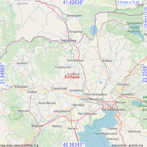
Evropós GPS coordinates[2]
40° 53' 49.308" North, 22° 33' 9.972" East
| Map corner | latitude | longitude |
|---|---|---|
| Upper-left | 41.42638°, | 21.84965° |
| Center: | 40.89703°, | 22.55277° |
| Lower-right: | 40.36341°, | 23.2559° |
| Map W x H: | 118.2×118.2 km | = 73.4×73.4mi |
| max Lat: | 41.72048° ⇑11.6% North |
| Evropós: | 40.89703° |
| min Lat: | ⇓88.4% South 34.8346° |
| min Long | Evropós | max Long |
| 19.40494° | 22.55277° | 29.59361° |
| W 41.8%⇐ | ⇒58.2% E |
Elevation
Elevation of Evropós is 84 m = 276 ft, and this is 84.9 m = 279 ft below average elevation for this country.
| Max E: |
1439 m = 4721 ft | 49.1% |
| Avg. | 168.9 m = 554 ft | |
| Evropós | 84 m = 276 ft | |
Min E: |
0 m = 0 ft | 50.9% |
See also: Greece elevation on elevation.city.
Geographical zone
Evropós is located in North temperate zone (between Tropic of Cancer and the Arctic Circle). Distance of this Northern Tropic circle is 1941.4 km =1206.3 mi to South.| Distance of | km | miles | from Evropós |
|---|---|---|---|
| North Pole | 5459.7 | 3392.5 | to North |
| Arctic Circle | 2853.9 | 1773.3 | to North |
| Tropic Cancer | 1941.4 | 1206.3 | to South |
| Equator | 4547.3 | 2825.6 | to South |


Nearby cities:
15 places around Evropós: (largest is in red/bold)
• Akropótamos
10.6 km =6.6 mi,  126°
126°
• Axioúpoli
9.9 km =6.2 mi,  354°
354°
• Gorgópi
7.5 km =4.7 mi,  341°
341°
• Gouménissa
10.2 km =6.3 mi,  302°
302°
• Gríva
13.6 km =8.5 mi, 298°
• Kastanás
12.4 km =7.7 mi, 134°
• Koufália
13.4 km =8.3 mi,  173°
173°
• Pentaplátano
14.2 km =8.8 mi,  232°
232°
• Polýkastro
10.9 km =6.8 mi,  7°
7°
• Próchoma
14.6 km =9.1 mi,  138°
138°
• Rachóna
9.5 km =5.9 mi,  187°
187°
• Toúmpa
4.3 km =2.7 mi, 349°
• Ágios Pétros
4.2 km =2.6 mi, 142°
• Áspros
6.5 km =4 mi,  86°
86°
• Áthyra
8.6 km =5.3 mi,  156°
156°
Sources, notices
• [Note1] Compared only with cities in Greece existing in our database
• [Src1] Map data: © OpenStreetMap contributors (CC-BY-SA)
• [Src2] Other city data from geonames.org with taken over terms of usage.
• [Src3] Geographical zone / Annual Mean Temperature by Robert A. Rohde @ Wikipedia
