Áthyra geodata
Áthyra (Central Macedonia) is a populated place; located in Greece in Europe/Athens (GMT+3) time zone. With population of 1,722 people, there are 590 cities with bigger population in this country. Compared to other cities in Greece, 86.5% of cities are located further ↓South; 57.1% of cities are located further →East and 71.8% of cities have higher elevation than Áthyra. Note1


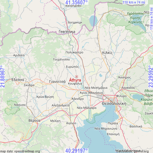
Áthyra GPS coordinates[2]
40° 49' 34.14" North, 22° 35' 34.044" East
| Map corner | latitude | longitude |
|---|---|---|
| Upper-left | 41.35607°, | 21.88967° |
| Center: | 40.82615°, | 22.59279° |
| Lower-right: | 40.29197°, | 23.29592° |
| Map W x H: | 118.3×118.3 km | = 73.5×73.5mi |
| max Lat: | 41.72048° ⇑13.5% North |
| Áthyra: | 40.82615° |
| min Lat: | ⇓86.5% South 34.8346° |
| min Long | Áthyra | max Long |
| 19.40494° | 22.59279° | 29.59361° |
| W 42.9%⇐ | ⇒57.1% E |
Elevation
Elevation of Áthyra is 28 m = 92 ft, and this is 140.9 m = 462 ft below average elevation for this country.
| Max E: |
1439 m = 4721 ft | 71.8% |
| Avg. | 168.9 m = 554 ft | |
| Áthyra | 28 m = 92 ft | |
Min E: |
0 m = 0 ft | 28.2% |
See also: Greece elevation on elevation.city.
Geographical zone
Áthyra is located in North temperate zone (between Tropic of Cancer and the Arctic Circle). Distance of this Northern Tropic circle is 1933.5 km =1201.4 mi to South.| Distance of | km | miles | from Áthyra |
|---|---|---|---|
| North Pole | 5467.6 | 3397.4 | to North |
| Arctic Circle | 2861.7 | 1778.2 | to North |
| Tropic Cancer | 1933.5 | 1201.4 | to South |
| Equator | 4539.4 | 2820.7 | to South |


Nearby cities:
15 places around Áthyra: (largest is in red/bold)
• Akropótamos
5.4 km =3.4 mi,  73°
73°
• Chalkidóna
10.5 km =6.5 mi,  176°
176°
• Eleoúsa
9.1 km =5.7 mi,  161°
161°
• Evropós
8.6 km =5.3 mi,  336°
336°
• Kastanás
5.6 km =3.5 mi,  97°
97°
• Koufália
5.7 km =3.5 mi,  198°
198°
• Néa Pélla
10.9 km =6.8 mi,  231°
231°
• Néo Agionéri
9.8 km =6.1 mi, 101°
• Palaió Agionéri
11.4 km =7.1 mi, 96°
• Próchoma
6.9 km =4.3 mi,  116°
116°
• Pélla
9.1 km =5.7 mi,  217°
217°
• Rachóna
4.8 km =3 mi,  251°
251°
• Vathýlakkos
11.6 km =7.2 mi, 122°
• Ágios Pétros
4.6 km =2.9 mi,  349°
349°
• Áspros
8.9 km =5.5 mi,  20°
20°
Sources, notices
• [Note1] Compared only with cities in Greece existing in our database
• [Src1] Map data: © OpenStreetMap contributors (CC-BY-SA)
• [Src2] Other city data from geonames.org with taken over terms of usage.
• [Src3] Geographical zone / Annual Mean Temperature by Robert A. Rohde @ Wikipedia
