Eleftherés geodata
Eleftherés (East Macedonia and Thrace) is a populated place; located in Greece in Europe/Athens (GMT+3) time zone. With population of 1,303 people, there are 768 cities with bigger population in this country. Compared to other cities in Greece, 87.2% of cities are located further ↓South; 81.7% of cities are located further ←West and 52.8% of cities have higher elevation than Eleftherés. Note1
Administrative division(s):
- Level 1: East Macedonia and Thrace
- Level 2: Nomós Kaválas
- Level 3: Dimos Pangaio


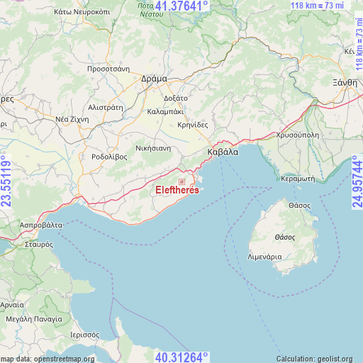
Eleftherés GPS coordinates[2]
40° 50' 47.976" North, 24° 15' 15.516" East
| Map corner | latitude | longitude |
|---|---|---|
| Upper-left | 41.37641°, | 23.55119° |
| Center: | 40.84666°, | 24.25431° |
| Lower-right: | 40.31264°, | 24.95744° |
| Map W x H: | 118.3×118.3 km | = 73.5×73.5mi |
| max Lat: | 41.72048° ⇑12.8% North |
| Eleftherés: | 40.84666° |
| min Lat: | ⇓87.2% South 34.8346° |
| min Long | Eleftherés | max Long |
| 19.40494° | 24.25431° | 29.59361° |
| W 81.7%⇐ | ⇒18.3% E |
Elevation
Elevation of Eleftherés is 71 m = 233 ft, and this is 97.9 m = 321 ft below average elevation for this country.
| Max E: |
1439 m = 4721 ft | 52.8% |
| Avg. | 168.9 m = 554 ft | |
| Eleftherés | 71 m = 233 ft | |
Min E: |
0 m = 0 ft | 47.2% |
See also: Greece elevation on elevation.city.
Geographical zone
Eleftherés is located in North temperate zone (between Tropic of Cancer and the Arctic Circle). Distance of this Northern Tropic circle is 1935.8 km =1202.8 mi to South.| Distance of | km | miles | from Eleftherés |
|---|---|---|---|
| North Pole | 5465.3 | 3396 | to North |
| Arctic Circle | 2859.5 | 1776.8 | to North |
| Tropic Cancer | 1935.8 | 1202.8 | to South |
| Equator | 4541.7 | 2822.1 | to South |


Nearby cities:
15 places around Eleftherés: (largest is in red/bold)
• Amisianá
11.9 km =7.4 mi,  36°
36°
• Antifílippoi
11.6 km =7.2 mi,  341°
341°
• Avlí
7 km =4.3 mi,  294°
294°
• Elaiochóri
3.1 km =1.9 mi,  196°
196°
• Eleftheroúpolis
7.5 km =4.7 mi,  358°
358°
• Foliá
9.2 km =5.7 mi,  243°
243°
• Georgianí
15.1 km =9.4 mi,  323°
323°
• Kokkinóchoma
10 km =6.2 mi,  26°
26°
• Mousthéni
12 km =7.5 mi,  278°
278°
• Nikísiani
14.6 km =9.1 mi, 320°
• Néa Iraklítsa
5.6 km =3.5 mi,  69°
69°
• Néa Péramos
4.1 km =2.5 mi,  102°
102°
• Palaiochóri
12.5 km =7.8 mi,  329°
329°
• Palaió Tsiflíki
10.4 km =6.5 mi,  51°
51°
• Panagiá
5.8 km =3.6 mi,  349°
349°
Sources, notices
• [Note1] Compared only with cities in Greece existing in our database
• [Src1] Map data: © OpenStreetMap contributors (CC-BY-SA)
• [Src2] Other city data from geonames.org with taken over terms of usage.
• [Src3] Geographical zone / Annual Mean Temperature by Robert A. Rohde @ Wikipedia
