Elaiochóri geodata
Elaiochóri (East Macedonia and Thrace) is a populated place; located in Greece in Europe/Athens (GMT+3) time zone. With population of 1,195 people, there are 832 cities with bigger population in this country. Compared to other cities in Greece, 86.3% of cities are located further ↓South; 81.5% of cities are located further ←West and 50.1% of cities have higher elevation than Elaiochóri. Note1
Administrative division(s):
- Level 1: East Macedonia and Thrace
- Level 2: Nomós Kaválas
- Level 3: Dimos Pangaio


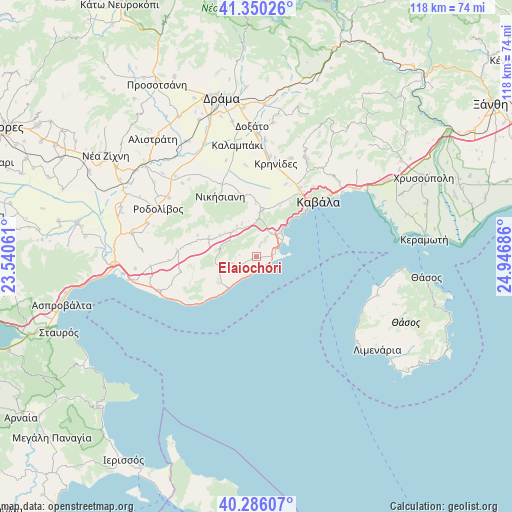
Elaiochóri GPS coordinates[2]
40° 49' 13.08" North, 24° 14' 37.428" East
| Map corner | latitude | longitude |
|---|---|---|
| Upper-left | 41.35026°, | 23.54061° |
| Center: | 40.8203°, | 24.24373° |
| Lower-right: | 40.28607°, | 24.94686° |
| Map W x H: | 118.3×118.3 km | = 73.5×73.5mi |
| max Lat: | 41.72048° ⇑13.7% North |
| Elaiochóri: | 40.8203° |
| min Lat: | ⇓86.3% South 34.8346° |
| min Long | Elaiochóri | max Long |
| 19.40494° | 24.24373° | 29.59361° |
| W 81.5%⇐ | ⇒18.5% E |
Elevation
Elevation of Elaiochóri is 81 m = 266 ft, and this is 87.9 m = 288 ft below average elevation for this country.
| Max E: |
1439 m = 4721 ft | 50.1% |
| Avg. | 168.9 m = 554 ft | |
| Elaiochóri | 81 m = 266 ft | |
Min E: |
0 m = 0 ft | 49.9% |
See also: Greece elevation on elevation.city.
Geographical zone
Elaiochóri is located in North temperate zone (between Tropic of Cancer and the Arctic Circle). Distance of this Northern Tropic circle is 1932.9 km =1201 mi to South.| Distance of | km | miles | from Elaiochóri |
|---|---|---|---|
| North Pole | 5468.3 | 3397.8 | to North |
| Arctic Circle | 2862.4 | 1778.6 | to North |
| Tropic Cancer | 1932.9 | 1201 | to South |
| Equator | 4538.8 | 2820.3 | to South |


Nearby cities:
15 places around Elaiochóri: (largest is in red/bold)
• Amisianá
14.8 km =9.2 mi,  32°
32°
• Antifílippoi
14.2 km =8.8 mi,  348°
348°
• Avlí
8 km =5 mi,  317°
317°
• Eleftheroúpolis
10.4 km =6.5 mi,  3°
3°
• Eleftherés
3.1 km =1.9 mi,  16°
16°
• Foliá
7.4 km =4.6 mi,  260°
260°
• Kokkinóchoma
13 km =8.1 mi, 24°
• Mousthéni
12 km =7.5 mi,  293°
293°
• Nikísiani
16.5 km =10.3 mi,  329°
329°
• Néa Iraklítsa
7.8 km =4.8 mi,  51°
51°
• Néa Péramos
5.3 km =3.3 mi,  67°
67°
• Palaiochóri
14.8 km =9.2 mi,  337°
337°
• Palaió Tsiflíki
13 km =8.1 mi,  43°
43°
• Panagiá
8.6 km =5.3 mi,  358°
358°
• Platanótopos
15.7 km =9.8 mi,  280°
280°
Sources, notices
• [Note1] Compared only with cities in Greece existing in our database
• [Src1] Map data: © OpenStreetMap contributors (CC-BY-SA)
• [Src2] Other city data from geonames.org with taken over terms of usage.
• [Src3] Geographical zone / Annual Mean Temperature by Robert A. Rohde @ Wikipedia
