Kokkinóchoma geodata
Kokkinóchoma (East Macedonia and Thrace) is a populated place; located in Greece in Europe/Athens (GMT+3) time zone. With population of 1,472 people, there are 680 cities with bigger population in this country. Compared to other cities in Greece, 89.3% of cities are located further ↓South; 82% of cities are located further ←West and 51.8% of cities have lower elevation than Kokkinóchoma. Note1
Administrative division(s):
- Level 1: East Macedonia and Thrace
- Level 2: Nomós Kaválas
- Level 3: Dimos Pangaio


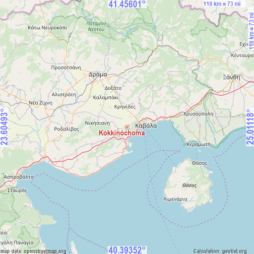
Kokkinóchoma GPS coordinates[2]
40° 55' 36.84" North, 24° 18' 28.98" East
| Map corner | latitude | longitude |
|---|---|---|
| Upper-left | 41.45601°, | 23.60493° |
| Center: | 40.9269°, | 24.30805° |
| Lower-right: | 40.39352°, | 25.01118° |
| Map W x H: | 118.1×118.1 km | = 73.4×73.4mi |
| max Lat: | 41.72048° ⇑10.7% North |
| Kokkinóchoma: | 40.9269° |
| min Lat: | ⇓89.3% South 34.8346° |
| min Long | Kokkinóchoma | max Long |
| 19.40494° | 24.30805° | 29.59361° |
| W 82%⇐ | ⇒18% E |
Elevation
Elevation of Kokkinóchoma is 88 m = 289 ft, and this is 80.9 m = 265 ft below average elevation for this country.
| Max E: |
1439 m = 4721 ft | 48.2% |
| Avg. | 168.9 m = 554 ft | |
| Kokkinóchoma | 88 m = 289 ft | |
Min E: |
0 m = 0 ft | 51.8% |
See also: Greece elevation on elevation.city.
Geographical zone
Kokkinóchoma is located in North temperate zone (between Tropic of Cancer and the Arctic Circle). Distance of this Northern Tropic circle is 1944.7 km =1208.4 mi to South.| Distance of | km | miles | from Kokkinóchoma |
|---|---|---|---|
| North Pole | 5456.4 | 3390.4 | to North |
| Arctic Circle | 2850.5 | 1771.2 | to North |
| Tropic Cancer | 1944.7 | 1208.4 | to South |
| Equator | 4550.6 | 2827.6 | to South |


Nearby cities:
15 places around Kokkinóchoma: (largest is in red/bold)
• Amisianá
2.6 km =1.6 mi,  75°
75°
• Amygdaleónas
6 km =3.7 mi,  47°
47°
• Antifílippoi
8.4 km =5.2 mi,  284°
284°
• Eleftheroúpolis
5 km =3.1 mi,  253°
253°
• Eleftherés
10 km =6.2 mi,  206°
206°
• Fílippoi
11.2 km =7 mi,  13°
13°
• Kavála
8.4 km =5.2 mi, 80°
• Krinídes
9.7 km =6 mi,  354°
354°
• Néa Iraklítsa
7 km =4.3 mi,  174°
174°
• Néa Péramos
9.8 km =6.1 mi,  183°
183°
• Palaiochóri
11.1 km =6.9 mi, 279°
• Palaió Tsiflíki
4.3 km =2.7 mi,  124°
124°
• Panagiá
6.4 km =4 mi,  239°
239°
• Prósfyges
8.6 km =5.3 mi,  40°
40°
• Zygós
11.4 km =7.1 mi,  32°
32°
Sources, notices
• [Note1] Compared only with cities in Greece existing in our database
• [Src1] Map data: © OpenStreetMap contributors (CC-BY-SA)
• [Src2] Other city data from geonames.org with taken over terms of usage.
• [Src3] Geographical zone / Annual Mean Temperature by Robert A. Rohde @ Wikipedia
