Elatochori geodata
Elatochori (Central Macedonia) is a populated place; located in Greece in Europe/Athens (GMT+3) time zone. With population of 681 people, there are 1441 cities with bigger population in this country. Compared to other cities in Greece, 70.5% of cities are located further ↓South; 66.1% of cities are located further →East and 97.7% of cities have lower elevation than Elatochori. Note1
Administrative division(s):
- Level 1: Central Macedonia
- Level 2: Nomós Pierías
- Level 3: Dimos Katerini


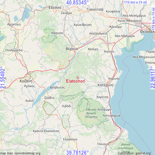
Elatochori GPS coordinates[2]
40° 19' 10.128" North, 22° 15' 28.944" East
| Map corner | latitude | longitude |
|---|---|---|
| Upper-left | 40.85345°, | 21.55492° |
| Center: | 40.31948°, | 22.25804° |
| Lower-right: | 39.78126°, | 22.96117° |
| Map W x H: | 119.2×119.2 km | = 74.1×74.1mi |
| max Lat: | 41.72048° ⇑29.5% North |
| Elatochori: | 40.31948° |
| min Lat: | ⇓70.5% South 34.8346° |
| min Long | Elatochori | max Long |
| 19.40494° | 22.25804° | 29.59361° |
| W 33.9%⇐ | ⇒66.1% E |
Elevation
Elevation of Elatochori is 827 m = 2713 ft, and this is 658.1 m = 2159 ft above average elevation for this country.
| Max E: |
1439 m = 4721 ft | 2.3% |
| Elatochori | 827 m 2713 ft | |
| Avg. | 168.9 m = 554 ft | |
Min E: |
0 m = 0 ft | 97.7% |
See also: Greece elevation on elevation.city.
Geographical zone
Elatochori is located in North temperate zone (between Tropic of Cancer and the Arctic Circle). Distance of this Northern Tropic circle is 1877.2 km =1166.4 mi to South.| Distance of | km | miles | from Elatochori |
|---|---|---|---|
| North Pole | 5524 | 3432.5 | to North |
| Arctic Circle | 2918.1 | 1813.2 | to North |
| Tropic Cancer | 1877.2 | 1166.4 | to South |
| Equator | 4483.1 | 2785.7 | to South |


Nearby cities:
15 places around Elatochori: (largest is in red/bold)
• Káto Miliá
10.3 km =6.4 mi,  135°
135°
• Lófos
13.3 km =8.3 mi,  128°
128°
• Moschopótamos
4.3 km =2.7 mi,  80°
80°
• Palaió Keramídi
17.5 km =10.9 mi,  91°
91°
• Polýmylos
17.1 km =10.6 mi,  289°
289°
• Ritíni
4.1 km =2.5 mi,  147°
147°
• Rizómata
5.3 km =3.3 mi,  310°
310°
• Ryákia
14.6 km =9.1 mi,  51°
51°
• Ráchi
18.7 km =11.6 mi,  348°
348°
• Sfikiá
8.5 km =5.3 mi,  330°
330°
• Svorónos
18.4 km =11.4 mi,  108°
108°
• Trílofos
17.9 km =11.1 mi,  71°
71°
• Velventós
17.1 km =10.6 mi,  245°
245°
• Ágios Dimítrios
18.4 km =11.4 mi,  187°
187°
• Élafos
13.3 km =8.3 mi,  62°
62°
Sources, notices
• [Note1] Compared only with cities in Greece existing in our database
• [Src1] Map data: © OpenStreetMap contributors (CC-BY-SA)
• [Src2] Other city data from geonames.org with taken over terms of usage.
• [Src3] Geographical zone / Annual Mean Temperature by Robert A. Rohde @ Wikipedia
