Élafos geodata
Élafos (Central Macedonia) is a populated place; located in Greece in Europe/Athens (GMT+3) time zone. With population of 621 people, there are 1546 cities with bigger population in this country. Compared to other cities in Greece, 71.5% of cities are located further ↓South; 62.6% of cities are located further →East and 83.9% of cities have lower elevation than Élafos. Note1
Administrative division(s):
- Level 1: Central Macedonia
- Level 2: Nomós Pierías
- Level 3: Dimos Katerini


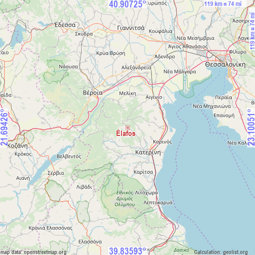
Élafos GPS coordinates[2]
40° 22' 25.392" North, 22° 23' 50.568" East
| Map corner | latitude | longitude |
|---|---|---|
| Upper-left | 40.90725°, | 21.69426° |
| Center: | 40.37372°, | 22.39738° |
| Lower-right: | 39.83593°, | 23.10051° |
| Map W x H: | 119.1×119.1 km | = 74×74mi |
| max Lat: | 41.72048° ⇑28.5% North |
| Élafos: | 40.37372° |
| min Lat: | ⇓71.5% South 34.8346° |
| min Long | Élafos | max Long |
| 19.40494° | 22.39738° | 29.59361° |
| W 37.4%⇐ | ⇒62.6% E |
Elevation
Elevation of Élafos is 355 m = 1165 ft, and this is 186.1 m = 611 ft above average elevation for this country.
| Max E: |
1439 m = 4721 ft | 16.1% |
| Élafos | 355 m 1165 ft | |
| Avg. | 168.9 m = 554 ft | |
Min E: |
0 m = 0 ft | 83.9% |
See also: Greece elevation on elevation.city.
Geographical zone
Élafos is located in North temperate zone (between Tropic of Cancer and the Arctic Circle). Distance of this Northern Tropic circle is 1883.2 km =1170.2 mi to South.| Distance of | km | miles | from Élafos |
|---|---|---|---|
| North Pole | 5517.9 | 3428.7 | to North |
| Arctic Circle | 2912 | 1809.4 | to North |
| Tropic Cancer | 1883.2 | 1170.2 | to South |
| Equator | 4489.1 | 2789.4 | to South |


Nearby cities:
15 places around Élafos: (largest is in red/bold)
• Alónia
12.3 km =7.6 mi,  79°
79°
• Andromáchi
13.3 km =8.3 mi,  147°
147°
• Elatochori
13.3 km =8.3 mi,  242°
242°
• Ganóchora
11 km =6.8 mi,  130°
130°
• Káto Ágios Ioánnis
12.1 km =7.5 mi,  115°
115°
• Moschopótamos
9.2 km =5.7 mi,  234°
234°
• Néa Trapezoúnta
11.6 km =7.2 mi,  112°
112°
• Palaiostáni
7.5 km =4.7 mi,  47°
47°
• Palaió Keramídi
8.7 km =5.4 mi,  139°
139°
• Palatítsia
13.1 km =8.1 mi,  339°
339°
• Ryákia
3 km =1.9 mi,  353°
353°
• Sevastí
12.6 km =7.8 mi,  97°
97°
• Svorónos
13 km =8.1 mi, 154°
• Trílofos
5.2 km =3.2 mi,  93°
93°
• Áno Ágios Ioánnis
10.1 km =6.3 mi, 126°
Sources, notices
• [Note1] Compared only with cities in Greece existing in our database
• [Src1] Map data: © OpenStreetMap contributors (CC-BY-SA)
• [Src2] Other city data from geonames.org with taken over terms of usage.
• [Src3] Geographical zone / Annual Mean Temperature by Robert A. Rohde @ Wikipedia
