Édessa geodata
Édessa (Central Macedonia) is a seat of a second-order administrative division; located in Greece in Europe/Athens (GMT+3) time zone. With population of 18,669 people, there are 96 cities with bigger population in this country. Compared to other cities in Greece, 85.5% of cities are located further ↓South; 71% of cities are located further →East and 81.8% of cities have lower elevation than Édessa. Note1


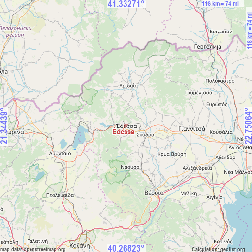
Édessa GPS coordinates[2]
40° 48' 9.36" North, 22° 2' 51.036" East
| Map corner | latitude | longitude |
|---|---|---|
| Upper-left | 41.33271°, | 21.34439° |
| Center: | 40.8026°, | 22.04751° |
| Lower-right: | 40.26823°, | 22.75064° |
| Map W x H: | 118.4×118.4 km | = 73.6×73.6mi |
| max Lat: | 41.72048° ⇑14.5% North |
| Édessa: | 40.8026° |
| min Lat: | ⇓85.5% South 34.8346° |
| min Long | Édessa | max Long |
| 19.40494° | 22.04751° | 29.59361° |
| W 29%⇐ | ⇒71% E |
Elevation
Elevation of Édessa is 312 m = 1024 ft, and this is 143.1 m = 469 ft above average elevation for this country.
| Max E: |
1439 m = 4721 ft | 18.2% |
| Édessa | 312 m 1024 ft | |
| Avg. | 168.9 m = 554 ft | |
Min E: |
0 m = 0 ft | 81.8% |
See also: Greece elevation on elevation.city.
Geographical zone
Édessa is located in North temperate zone (between Tropic of Cancer and the Arctic Circle). Distance of this Northern Tropic circle is 1930.9 km =1199.8 mi to South.| Distance of | km | miles | from Édessa |
|---|---|---|---|
| North Pole | 5470.2 | 3399 | to North |
| Arctic Circle | 2864.4 | 1779.9 | to North |
| Tropic Cancer | 1930.9 | 1199.8 | to South |
| Equator | 4536.8 | 2819 | to South |


Nearby cities:
15 places around Édessa: (largest is in red/bold)
• Flamouriá
6.1 km =3.8 mi,  204°
204°
• Kalí
11.1 km =6.9 mi,  80°
80°
• Káto Lipochóri
12.2 km =7.6 mi,  114°
114°
• Marína
13.1 km =8.1 mi,  159°
159°
• Mavrovoúni
9.4 km =5.8 mi,  103°
103°
• Mesiméri
2.1 km =1.3 mi,  241°
241°
• Petraía
12.3 km =7.6 mi,  138°
138°
• Profítis Ilías
9.7 km =6 mi, 82°
• Rizári
4 km =2.5 mi,  121°
121°
• Rizó
10.8 km =6.7 mi, 135°
• Rodochóri
12.7 km =7.9 mi,  191°
191°
• Sevastianá
7.4 km =4.6 mi, 120°
• Skýdra
9.6 km =6 mi, 114°
• Ágras
3.7 km =2.3 mi,  274°
274°
• Ápsalos
10 km =6.2 mi,  4°
4°
Sources, notices
• [Note1] Compared only with cities in Greece existing in our database
• [Src1] Map data: © OpenStreetMap contributors (CC-BY-SA)
• [Src2] Other city data from geonames.org with taken over terms of usage.
• [Src3] Geographical zone / Annual Mean Temperature by Robert A. Rohde @ Wikipedia
