Petraía geodata
Petraía (Central Macedonia) is a populated place; located in Greece in Europe/Athens (GMT+3) time zone. With population of 939 people, there are 1081 cities with bigger population in this country. Compared to other cities in Greece, 82.1% of cities are located further ↓South; 68.8% of cities are located further →East and 55.7% of cities have higher elevation than Petraía. Note1


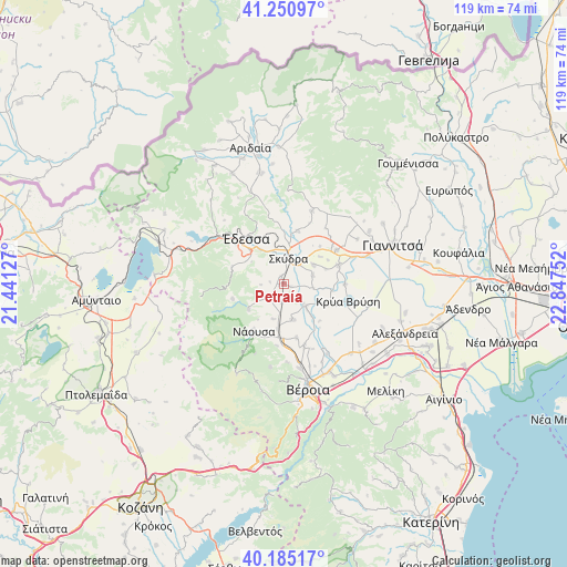
Petraía GPS coordinates[2]
40° 43' 12.72" North, 22° 8' 39.804" East
| Map corner | latitude | longitude |
|---|---|---|
| Upper-left | 41.25097°, | 21.44127° |
| Center: | 40.7202°, | 22.14439° |
| Lower-right: | 40.18517°, | 22.84752° |
| Map W x H: | 118.5×118.5 km | = 73.6×73.6mi |
| max Lat: | 41.72048° ⇑17.9% North |
| Petraía: | 40.7202° |
| min Lat: | ⇓82.1% South 34.8346° |
| min Long | Petraía | max Long |
| 19.40494° | 22.14439° | 29.59361° |
| W 31.2%⇐ | ⇒68.8% E |
Elevation
Elevation of Petraía is 64 m = 210 ft, and this is 104.9 m = 344 ft below average elevation for this country.
| Max E: |
1439 m = 4721 ft | 55.7% |
| Avg. | 168.9 m = 554 ft | |
| Petraía | 64 m = 210 ft | |
Min E: |
0 m = 0 ft | 44.3% |
See also: Greece elevation on elevation.city.
Geographical zone
Petraía is located in North temperate zone (between Tropic of Cancer and the Arctic Circle). Distance of this Northern Tropic circle is 1921.7 km =1194.1 mi to South.| Distance of | km | miles | from Petraía |
|---|---|---|---|
| North Pole | 5479.4 | 3404.7 | to North |
| Arctic Circle | 2873.5 | 1785.5 | to North |
| Tropic Cancer | 1921.7 | 1194.1 | to South |
| Equator | 4527.7 | 2813.4 | to South |


Nearby cities:
15 places around Petraía: (largest is in red/bold)
• Angelochóri
6.5 km =4 mi,  134°
134°
• Arsénio
1.4 km =0.9 mi,  118°
118°
• Eirinoúpoli
6.2 km =3.9 mi,  138°
138°
• Episkopí
3.7 km =2.3 mi,  190°
190°
• Kalývia
7.3 km =4.5 mi,  57°
57°
• Káto Lipochóri
5.1 km =3.2 mi,  35°
35°
• Lefkádia
7.8 km =4.8 mi,  195°
195°
• Marína
4.8 km =3 mi,  229°
229°
• Mavrovoúni
7 km =4.3 mi,  8°
8°
• Polyplátanos
5.7 km =3.5 mi, 136°
• Rizó
1.6 km =1 mi,  336°
336°
• Sevastianá
5.7 km =3.5 mi, 341°
• Skýdra
5.3 km =3.3 mi, 6°
• Stavrodrómi
6.2 km =3.9 mi,  98°
98°
• Áspro
6.2 km =3.9 mi,  73°
73°
Sources, notices
• [Note1] Compared only with cities in Greece existing in our database
• [Src1] Map data: © OpenStreetMap contributors (CC-BY-SA)
• [Src2] Other city data from geonames.org with taken over terms of usage.
• [Src3] Geographical zone / Annual Mean Temperature by Robert A. Rohde @ Wikipedia
