Anchíalos geodata
Anchíalos (Central Macedonia) is a populated place; located in Greece in Europe/Athens (GMT+3) time zone. With population of 852 people, there are 1194 cities with bigger population in this country. Compared to other cities in Greece, 81.8% of cities are located further ↓South; 52.4% of cities are located further →East and 77.6% of cities have higher elevation than Anchíalos. Note1
Administrative division(s):
- Level 1: Central Macedonia
- Level 2: Nomós Thessaloníkis
- Level 3: Dimos Chalkidona


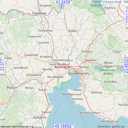
Anchíalos GPS coordinates[2]
40° 42' 54.324" North, 22° 46' 48.432" East
| Map corner | latitude | longitude |
|---|---|---|
| Upper-left | 41.2459°, | 22.077° |
| Center: | 40.71509°, | 22.78012° |
| Lower-right: | 40.18002°, | 23.48325° |
| Map W x H: | 118.5×118.5 km | = 73.6×73.6mi |
| max Lat: | 41.72048° ⇑18.2% North |
| Anchíalos: | 40.71509° |
| min Lat: | ⇓81.8% South 34.8346° |
| min Long | Anchíalos | max Long |
| 19.40494° | 22.78012° | 29.59361° |
| W 47.6%⇐ | ⇒52.4% E |
Elevation
Elevation of Anchíalos is 20 m = 66 ft, and this is 148.9 m = 489 ft below average elevation for this country.
| Max E: |
1439 m = 4721 ft | 77.6% |
| Avg. | 168.9 m = 554 ft | |
| Anchíalos | 20 m = 66 ft | |
Min E: |
0 m = 0 ft | 22.4% |
See also: Greece elevation on elevation.city.
Geographical zone
Anchíalos is located in North temperate zone (between Tropic of Cancer and the Arctic Circle). Distance of this Northern Tropic circle is 1921.2 km =1193.8 mi to South.| Distance of | km | miles | from Anchíalos |
|---|---|---|---|
| North Pole | 5480 | 3405.1 | to North |
| Arctic Circle | 2874.1 | 1785.9 | to North |
| Tropic Cancer | 1921.2 | 1193.8 | to South |
| Equator | 4527.1 | 2813 | to South |


Nearby cities:
15 places around Anchíalos: (largest is in red/bold)
• Anatolikó
8.3 km =5.2 mi,  223°
223°
• Chalástra
10.6 km =6.6 mi,  201°
201°
• Diavatá
7.2 km =4.5 mi,  115°
115°
• Géfyra
7.5 km =4.7 mi,  284°
284°
• Kalochóri
10.4 km =6.5 mi,  141°
141°
• Neochoroúda
8.4 km =5.2 mi,  72°
72°
• Néa Filadélfeia
10.5 km =6.5 mi,  28°
28°
• Néa Magnisía
6.3 km =3.9 mi, 118°
• Néa Mesimvría
4.2 km =2.6 mi,  347°
347°
• Oraiókastro
11.7 km =7.3 mi,  81°
81°
• Pentálofos
6.8 km =4.2 mi,  63°
63°
• Síndos
5.4 km =3.4 mi,  156°
156°
• Vathýlakkos
8.5 km =5.3 mi,  315°
315°
• Xirochóri
9.8 km =6.1 mi,  359°
359°
• Ágios Athanásios
4.4 km =2.7 mi,  271°
271°
Sources, notices
• [Note1] Compared only with cities in Greece existing in our database
• [Src1] Map data: © OpenStreetMap contributors (CC-BY-SA)
• [Src2] Other city data from geonames.org with taken over terms of usage.
• [Src3] Geographical zone / Annual Mean Temperature by Robert A. Rohde @ Wikipedia
