Tocoa geodata
Tocoa (Colón) is a populated place; located in Honduras in America/Tegucigalpa (GMT-6) time zone. With population of 30,785 people, there are 13 cities with bigger population in this country. Compared to other cities in Honduras, 91% of cities are located further ↓South; 93% of cities are located further ←West and 86.8% of cities have higher elevation than Tocoa. Note1


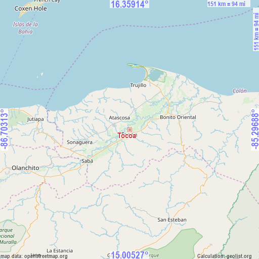
Tocoa GPS coordinates[2]
15° 40' 59.988" North, 86° 0' 0" West
| Map corner | latitude | longitude |
|---|---|---|
| Upper-left | 16.35914°, | -86.70313° |
| Center: | 15.68333°, | -86° |
| Lower-right: | 15.00527°, | -85.29688° |
| Map W x H: | 150.5×150.5 km | = 93.5×93.5mi |
| max Lat: | 16.45° ⇑9% North |
| Tocoa: | 15.68333° |
| min Lat: | ⇓91% South 13.11667° |
| min Long | Tocoa | max Long |
| -89.23333° | -86° | -83.23333° |
| W 93%⇐ | ⇒7% E |
Elevation
Elevation of Tocoa is 37 m = 121 ft, and this is 524.2 m = 1720 ft below average elevation for this country.
| Max E: |
1811 m = 5942 ft | 86.8% |
| Avg. | 561.2 m = 1841 ft | |
| Tocoa | 37 m = 121 ft | |
Min E: |
1 m = 3 ft | 13.2% |
See also: Honduras elevation on elevation.city.
Geographical zone
Tocoa is located in North Torrid zone (between Equator and Tropic of Cancer). Distance of this Northern Tropic circle is 862.1 km =535.7 mi to North.| Distance of | km | miles | from Tocoa |
|---|---|---|---|
| North Pole | 8263.2 | 5134.5 | to North |
| Arctic Circle | 5657.4 | 3515.3 | to North |
| Tropic Cancer | 862.1 | 535.7 | to North |
| Equator | 1743.8 | 1083.5 | to South |


Nearby cities:
15 places around Tocoa: (largest is in red/bold)
• Bonito Oriental
29.2 km =18.1 mi,  75°
75°
• Corocito
24.3 km =15.1 mi,  72°
72°
• Jericó
29.9 km =18.6 mi,  6°
6°
• La Brea
13.5 km =8.4 mi,  15°
15°
• La Curva
28.1 km =17.5 mi,  62°
62°
• La Esperanza
25.6 km =15.9 mi,  102°
102°
• Prieta
18.6 km =11.6 mi,  232°
232°
• Puerto Castilla
37.2 km =23.1 mi, 5°
• Quebrada de Arena
12.9 km =8 mi,  43°
43°
• Río Esteban
36.2 km =22.5 mi,  297°
297°
• Sabá
36 km =22.4 mi, 228°
• Salamá
8.2 km =5.1 mi,  25°
25°
• Taujica
9.1 km =5.7 mi, 78°
• Trujillo
26.4 km =16.4 mi, 10°
• Zamora
9 km =5.6 mi, 232°
Sources, notices
• [Note1] Compared only with cities in Honduras existing in our database
• [Src1] Map data: © OpenStreetMap contributors (CC-BY-SA)
• [Src2] Other city data from geonames.org with taken over terms of usage.
• [Src3] Geographical zone / Annual Mean Temperature by Robert A. Rohde @ Wikipedia
