Río Esteban geodata
Río Esteban (Colón) is a populated place; located in Honduras in America/Tegucigalpa (GMT-6) time zone. With population of 1,208 people, there are 320 cities with bigger population in this country. Compared to other cities in Honduras, 97% of cities are located further ↓South; 89.6% of cities are located further ←West and 98.8% of cities have higher elevation than Río Esteban. Note1


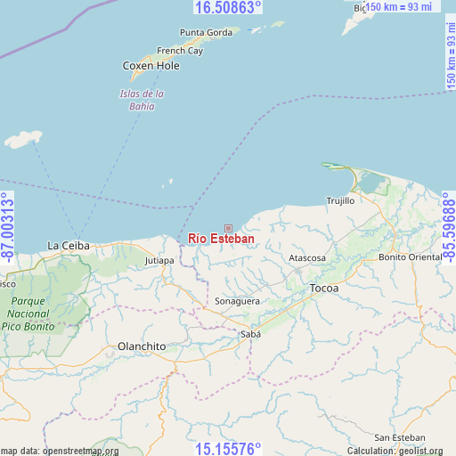
Río Esteban GPS coordinates[2]
15° 49' 59.988" North, 86° 18' 0" West
| Map corner | latitude | longitude |
|---|---|---|
| Upper-left | 16.50863°, | -87.00313° |
| Center: | 15.83333°, | -86.3° |
| Lower-right: | 15.15576°, | -85.59688° |
| Map W x H: | 150.4×150.4 km | = 93.5×93.5mi |
| max Lat: | 16.45° ⇑3% North |
| Río Esteban: | 15.83333° |
| min Lat: | ⇓97% South 13.11667° |
| min Long | Río Esteban | max Long |
| -89.23333° | -86.3° | -83.23333° |
| W 89.6%⇐ | ⇒10.4% E |
Elevation
Elevation of Río Esteban is 4 m = 13 ft, and this is 557.2 m = 1828 ft below average elevation for this country.
| Max E: |
1811 m = 5942 ft | 98.8% |
| Avg. | 561.2 m = 1841 ft | |
| Río Esteban | 4 m = 13 ft | |
Min E: |
1 m = 3 ft | 1.2% |
See also: Honduras elevation on elevation.city.
Geographical zone
Río Esteban is located in North Torrid zone (between Equator and Tropic of Cancer). Distance of this Northern Tropic circle is 845.4 km =525.3 mi to North.| Distance of | km | miles | from Río Esteban |
|---|---|---|---|
| North Pole | 8246.6 | 5124.2 | to North |
| Arctic Circle | 5640.7 | 3505 | to North |
| Tropic Cancer | 845.4 | 525.3 | to North |
| Equator | 1760.5 | 1093.9 | to South |


Nearby cities:
15 places around Río Esteban: (largest is in red/bold)
• Bálsamo Oriental
39.1 km =24.3 mi,  185°
185°
• Carbajales
35.6 km =22.1 mi, 188°
• Elíxir
38.9 km =24.2 mi,  180°
180°
• Jericó
37.9 km =23.5 mi,  70°
70°
• Jutiapa
24.3 km =15.1 mi,  252°
252°
• La Brea
35.9 km =22.3 mi,  95°
95°
• Nueva Armenia
21.6 km =13.4 mi,  258°
258°
• Piedras Amarillas
33.1 km =20.6 mi,  239°
239°
• Prieta
33.1 km =20.6 mi,  148°
148°
• Puerto Castilla
41.1 km =25.5 mi,  60°
60°
• Salamá
36.8 km =22.9 mi, 104°
• Sambo Creek
41 km =25.5 mi,  267°
267°
• Tocoa
36.2 km =22.5 mi,  117°
117°
• Trujillo
38.1 km =23.7 mi,  75°
75°
• Zamora
33.4 km =20.8 mi,  131°
131°
Sources, notices
• [Note1] Compared only with cities in Honduras existing in our database
• [Src1] Map data: © OpenStreetMap contributors (CC-BY-SA)
• [Src2] Other city data from geonames.org with taken over terms of usage.
• [Src3] Geographical zone / Annual Mean Temperature by Robert A. Rohde @ Wikipedia
