Trujillo geodata
Trujillo (Colón) is a seat of a first-order administrative division; located in Honduras in America/Tegucigalpa (GMT-6) time zone. With population of 9,646 people, there are 34 cities with bigger population in this country. Compared to other cities in Honduras, 98.4% of cities are located further ↓South; 94.6% of cities are located further ←West and 87.4% of cities have higher elevation than Trujillo. Note1


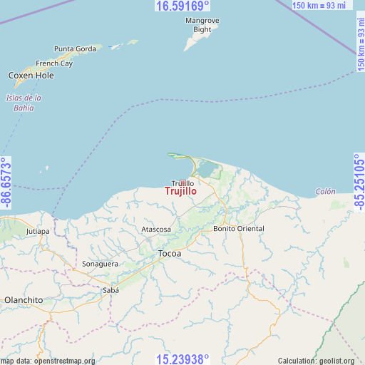
Trujillo GPS coordinates[2]
15° 55' 0.012" North, 85° 57' 15.012" West
| Map corner | latitude | longitude |
|---|---|---|
| Upper-left | 16.59169°, | -86.6573° |
| Center: | 15.91667°, | -85.95417° |
| Lower-right: | 15.23938°, | -85.25105° |
| Map W x H: | 150.4×150.4 km | = 93.5×93.5mi |
| max Lat: | 16.45° ⇑1.6% North |
| Trujillo: | 15.91667° |
| min Lat: | ⇓98.4% South 13.11667° |
| min Long | Trujillo | max Long |
| -89.23333° | -85.95417° | -83.23333° |
| W 94.6%⇐ | ⇒5.4% E |
Elevation
Elevation of Trujillo is 35 m = 115 ft, and this is 526.2 m = 1726 ft below average elevation for this country.
| Max E: |
1811 m = 5942 ft | 87.4% |
| Avg. | 561.2 m = 1841 ft | |
| Trujillo | 35 m = 115 ft | |
Min E: |
1 m = 3 ft | 12.6% |
See also: Honduras elevation on elevation.city.
Geographical zone
Trujillo is located in North Torrid zone (between Equator and Tropic of Cancer). Distance of this Northern Tropic circle is 836.2 km =519.6 mi to North.| Distance of | km | miles | from Trujillo |
|---|---|---|---|
| North Pole | 8237.3 | 5118.4 | to North |
| Arctic Circle | 5631.4 | 3499.2 | to North |
| Tropic Cancer | 836.2 | 519.6 | to North |
| Equator | 1769.8 | 1099.7 | to South |


Nearby cities:
15 places around Trujillo: (largest is in red/bold)
• Bonito Oriental
30 km =18.6 mi,  128°
128°
• Corocito
26 km =16.2 mi,  135°
135°
• Francia
40.3 km =25 mi,  100°
100°
• Jericó
3.9 km =2.4 mi,  340°
340°
• La Brea
13 km =8.1 mi,  185°
185°
• La Curva
23.9 km =14.9 mi,  122°
122°
• La Esperanza
37.4 km =23.2 mi,  147°
147°
• Puerto Castilla
11.2 km =7 mi,  353°
353°
• Quebrada de Arena
17.2 km =10.7 mi,  166°
166°
• Río Esteban
38.1 km =23.7 mi,  255°
255°
• Salamá
18.6 km =11.6 mi,  184°
184°
• Santa Rosa de Aguán
25.7 km =16 mi,  81°
81°
• Taujica
24.4 km =15.2 mi, 170°
• Tocoa
26.4 km =16.4 mi, 190°
• Zamora
33.7 km =20.9 mi,  200°
200°
Sources, notices
• [Note1] Compared only with cities in Honduras existing in our database
• [Src1] Map data: © OpenStreetMap contributors (CC-BY-SA)
• [Src2] Other city data from geonames.org with taken over terms of usage.
• [Src3] Geographical zone / Annual Mean Temperature by Robert A. Rohde @ Wikipedia
