Salamá geodata
Salamá (Colón) is a populated place; located in Honduras in America/Tegucigalpa (GMT-6) time zone. With population of 1,737 people, there are 211 cities with bigger population in this country. Compared to other cities in Honduras, 93% of cities are located further ↓South; 93.6% of cities are located further ←West and 89.8% of cities have higher elevation than Salamá. Note1


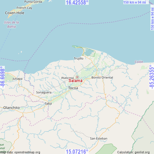
Salamá GPS coordinates[2]
15° 45' 0" North, 85° 58' 0.012" West
| Map corner | latitude | longitude |
|---|---|---|
| Upper-left | 16.42558°, | -86.6698° |
| Center: | 15.75°, | -85.96667° |
| Lower-right: | 15.07216°, | -85.26355° |
| Map W x H: | 150.5×150.5 km | = 93.5×93.5mi |
| max Lat: | 16.45° ⇑7% North |
| Salamá: | 15.75° |
| min Lat: | ⇓93% South 13.11667° |
| min Long | Salamá | max Long |
| -89.23333° | -85.96667° | -83.23333° |
| W 93.6%⇐ | ⇒6.4% E |
Elevation
Elevation of Salamá is 25 m = 82 ft, and this is 536.2 m = 1759 ft below average elevation for this country.
| Max E: |
1811 m = 5942 ft | 89.8% |
| Avg. | 561.2 m = 1841 ft | |
| Salamá | 25 m = 82 ft | |
Min E: |
1 m = 3 ft | 10.2% |
See also: Honduras elevation on elevation.city.
Geographical zone
Salamá is located in North Torrid zone (between Equator and Tropic of Cancer). Distance of this Northern Tropic circle is 854.7 km =531.1 mi to North.| Distance of | km | miles | from Salamá |
|---|---|---|---|
| North Pole | 8255.8 | 5129.9 | to North |
| Arctic Circle | 5649.9 | 3510.7 | to North |
| Tropic Cancer | 854.7 | 531.1 | to North |
| Equator | 1751.2 | 1088.1 | to South |


Nearby cities:
15 places around Salamá: (largest is in red/bold)
• Bonito Oriental
24.7 km =15.3 mi,  90°
90°
• Corocito
19.6 km =12.2 mi, 90°
• Jericó
22.2 km =13.8 mi,  0°
0°
• La Brea
5.6 km =3.5 mi, 0°
• La Curva
22.1 km =13.7 mi,  75°
75°
• La Esperanza
25 km =15.5 mi,  121°
121°
• Prieta
26.2 km =16.3 mi,  224°
224°
• Puerto Castilla
29.7 km =18.5 mi, 0°
• Quebrada de Arena
5.7 km =3.5 mi,  70°
70°
• Río Esteban
36.8 km =22.9 mi,  284°
284°
• Santa Rosa de Aguán
34.8 km =21.6 mi,  50°
50°
• Taujica
7.7 km =4.8 mi,  136°
136°
• Tocoa
8.2 km =5.1 mi,  205°
205°
• Trujillo
18.6 km =11.6 mi, 4°
• Zamora
16.8 km =10.4 mi, 219°
Sources, notices
• [Note1] Compared only with cities in Honduras existing in our database
• [Src1] Map data: © OpenStreetMap contributors (CC-BY-SA)
• [Src2] Other city data from geonames.org with taken over terms of usage.
• [Src3] Geographical zone / Annual Mean Temperature by Robert A. Rohde @ Wikipedia
