La Guata geodata
La Guata (Olancho) is a populated place; located in Honduras in America/Tegucigalpa (GMT-6) time zone. With population of 1,217 people, there are 317 cities with bigger population in this country. Compared to other cities in Honduras, 63.2% of cities are located further ↓South; 87.4% of cities are located further ←West and 80.2% of cities have lower elevation than La Guata. Note1


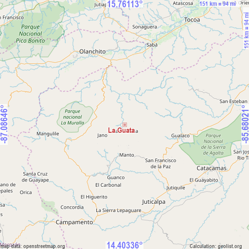
La Guata GPS coordinates[2]
15° 4' 59.988" North, 86° 22' 59.988" West
| Map corner | latitude | longitude |
|---|---|---|
| Upper-left | 15.76113°, | -87.08646° |
| Center: | 15.08333°, | -86.38333° |
| Lower-right: | 14.40336°, | -85.68021° |
| Map W x H: | 151×151 km | = 93.8×93.8mi |
| max Lat: | 16.45° ⇑36.8% North |
| La Guata: | 15.08333° |
| min Lat: | ⇓63.2% South 13.11667° |
| min Long | La Guata | max Long |
| -89.23333° | -86.38333° | -83.23333° |
| W 87.4%⇐ | ⇒12.6% E |
Elevation
Elevation of La Guata is 934 m = 3064 ft, and this is 372.8 m = 1223 ft above average elevation for this country.
| Max E: |
1811 m = 5942 ft | 19.8% |
| La Guata | 934 m 3064 ft | |
| Avg. | 561.2 m = 1841 ft | |
Min E: |
1 m = 3 ft | 80.2% |
See also: Honduras elevation on elevation.city.
Geographical zone
La Guata is located in North Torrid zone (between Equator and Tropic of Cancer). Distance of this Northern Tropic circle is 928.8 km =577.1 mi to North.| Distance of | km | miles | from La Guata |
|---|---|---|---|
| North Pole | 8330 | 5176 | to North |
| Arctic Circle | 5724.1 | 3556.8 | to North |
| Tropic Cancer | 928.8 | 577.1 | to North |
| Equator | 1677.1 | 1042.1 | to South |


Nearby cities:
15 places around La Guata: (largest is in red/bold)
• Armenia
42.7 km =26.5 mi,  2°
2°
• Buenos Aires
42.7 km =26.5 mi,  357°
357°
• Chirinos
41.2 km =25.6 mi,  328°
328°
• El Juncal
41.1 km =25.5 mi,  352°
352°
• El Ocote
42 km =26.1 mi, 332°
• El Rosario
38.1 km =23.7 mi,  237°
237°
• Gualaco
34.2 km =21.3 mi,  100°
100°
• Guarizama
19.3 km =12 mi,  163°
163°
• La Estancia
5.2 km =3.2 mi,  136°
136°
• Manto
18.5 km =11.5 mi,  180°
180°
• Salamá
35.1 km =21.8 mi,  217°
217°
• San Francisco de la Paz
28.3 km =17.6 mi, 135°
• Silca
32.1 km =19.9 mi,  210°
210°
• Teguajinal
39.2 km =24.4 mi,  323°
323°
• Tepusteca
37.7 km =23.4 mi,  10°
10°
Sources, notices
• [Note1] Compared only with cities in Honduras existing in our database
• [Src1] Map data: © OpenStreetMap contributors (CC-BY-SA)
• [Src2] Other city data from geonames.org with taken over terms of usage.
• [Src3] Geographical zone / Annual Mean Temperature by Robert A. Rohde @ Wikipedia
