San Pedro de Tutule geodata
San Pedro de Tutule (La Paz) is a populated place; located in Honduras in America/Tegucigalpa (GMT-6) time zone. With population of 1,876 people, there are 196 cities with bigger population in this country. Compared to other cities in Honduras, 79.8% of cities are located further ↑North; 57.6% of cities are located further →East and 93.6% of cities have lower elevation than San Pedro de Tutule. Note1


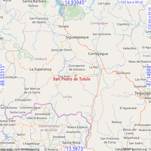
San Pedro de Tutule GPS coordinates[2]
14° 15' 0" North, 87° 51' 0" West
| Map corner | latitude | longitude |
|---|---|---|
| Upper-left | 14.93045°, | -88.55313° |
| Center: | 14.25°, | -87.85° |
| Lower-right: | 13.5675°, | -87.14688° |
| Map W x H: | 151.5×151.5 km | = 94.1×94.1mi |
| max Lat: | 16.45° ⇑79.8% North |
| San Pedro de Tutule: | 14.25° |
| min Lat: | ⇓20.2% South 13.11667° |
| min Long | San Pedro de Tu | max Long |
| -89.23333° | -87.85° | -83.23333° |
| W 42.4%⇐ | ⇒57.6% E |
Elevation
Elevation of San Pedro de Tutule is 1257 m = 4124 ft, and this is 695.8 m = 2283 ft above average elevation for this country.
| Max E: |
1811 m = 5942 ft | 6.4% |
| San Pedro de Tutule | 1257 m 4124 ft | |
| Avg. | 561.2 m = 1841 ft | |
Min E: |
1 m = 3 ft | 93.6% |
See also: Honduras elevation on elevation.city.
Geographical zone
San Pedro de Tutule is located in North Torrid zone (between Equator and Tropic of Cancer). Distance of this Northern Tropic circle is 1021.5 km =634.7 mi to North.| Distance of | km | miles | from San Pedro de Tutule |
|---|---|---|---|
| North Pole | 8422.6 | 5233.6 | to North |
| Arctic Circle | 5816.7 | 3614.3 | to North |
| Tropic Cancer | 1021.5 | 634.7 | to North |
| Equator | 1584.5 | 984.6 | to South |


Nearby cities:
15 places around San Pedro de Tutule: (largest is in red/bold)
• Ajuterique
21.9 km =13.6 mi,  47°
47°
• Cane
20.1 km =12.5 mi,  79°
79°
• La Florida
24.9 km =15.5 mi,  215°
215°
• La Paz
20 km =12.4 mi,  67°
67°
• Lamaní
25.8 km =16 mi,  102°
102°
• Lejamaní
20.7 km =12.9 mi, 51°
• Los Planes
28.6 km =17.8 mi, 218°
• Marcala
22.7 km =14.1 mi,  240°
240°
• San José
10.8 km =6.7 mi,  270°
270°
• San José de Pane
26 km =16.2 mi,  3°
3°
• San Sebastián
23.4 km =14.5 mi,  90°
90°
• Santiago Puringla
12.4 km =7.7 mi,  334°
334°
• Tepanguare
14.2 km =8.8 mi, 49°
• Villa de San Antonio
26.2 km =16.3 mi, 73°
• Yarumela
25.1 km =15.6 mi, 68°
Sources, notices
• [Note1] Compared only with cities in Honduras existing in our database
• [Src1] Map data: © OpenStreetMap contributors (CC-BY-SA)
• [Src2] Other city data from geonames.org with taken over terms of usage.
• [Src3] Geographical zone / Annual Mean Temperature by Robert A. Rohde @ Wikipedia
