La Paz geodata
La Paz is a seat of a first-order administrative division; located in Honduras in America/Tegucigalpa (GMT-6) time zone. With population of 17,555 people, there are 20 cities with bigger population in this country. Compared to other cities in Honduras, 76.6% of cities are located further ↑North; 52.4% of cities are located further →East and 61.2% of cities have lower elevation than La Paz. Note1


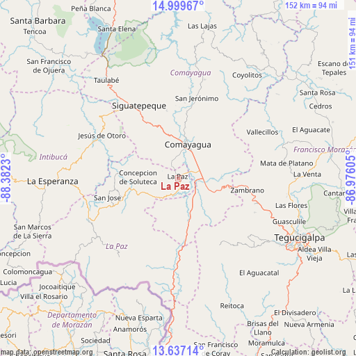
La Paz GPS coordinates[2]
14° 19' 9.984" North, 87° 40' 45.012" West
| Map corner | latitude | longitude |
|---|---|---|
| Upper-left | 14.99967°, | -88.3823° |
| Center: | 14.31944°, | -87.67917° |
| Lower-right: | 13.63714°, | -86.97605° |
| Map W x H: | 151.5×151.5 km | = 94.1×94.1mi |
| max Lat: | 16.45° ⇑76.6% North |
| La Paz: | 14.31944° |
| min Lat: | ⇓23.4% South 13.11667° |
| min Long | La Paz | max Long |
| -89.23333° | -87.67917° | -83.23333° |
| W 47.6%⇐ | ⇒52.4% E |
Elevation
Elevation of La Paz is 688 m = 2257 ft, and this is 126.8 m = 416 ft above average elevation for this country.
| Max E: |
1811 m = 5942 ft | 38.8% |
| La Paz | 688 m 2257 ft | |
| Avg. | 561.2 m = 1841 ft | |
Min E: |
1 m = 3 ft | 61.2% |
See also: Honduras elevation on elevation.city.
Geographical zone
La Paz is located in North Torrid zone (between Equator and Tropic of Cancer). Distance of this Northern Tropic circle is 1013.7 km =629.9 mi to North.| Distance of | km | miles | from La Paz |
|---|---|---|---|
| North Pole | 8414.9 | 5228.8 | to North |
| Arctic Circle | 5809 | 3609.5 | to North |
| Tropic Cancer | 1013.7 | 629.9 | to North |
| Equator | 1592.2 | 989.3 | to South |


Nearby cities:
15 places around La Paz: (largest is in red/bold)
• Ajuterique
7.4 km =4.6 mi,  342°
342°
• Cane
4.2 km =2.6 mi,  161°
161°
• Comayagua
15.3 km =9.5 mi,  17°
17°
• El Sauce
23.3 km =14.5 mi,  3°
3°
• Flores
12.8 km =8 mi,  108°
108°
• Lamaní
14.9 km =9.3 mi,  153°
153°
• Las Mercedes
12.8 km =8 mi, 108°
• Lejamaní
5.7 km =3.5 mi, 336°
• Palo Pintado
21.9 km =13.6 mi,  358°
358°
• San Pedro de Tutule
20 km =12.4 mi,  247°
247°
• San Sebastián
9.2 km =5.7 mi, 147°
• Tepanguare
7.8 km =4.8 mi,  281°
281°
• Valle de Ángeles
20.7 km =12.9 mi,  13°
13°
• Villa de San Antonio
6.7 km =4.2 mi,  92°
92°
• Yarumela
5.2 km =3.2 mi,  72°
72°
Sources, notices
• [Note1] Compared only with cities in Honduras existing in our database
• [Src1] Map data: © OpenStreetMap contributors (CC-BY-SA)
• [Src2] Other city data from geonames.org with taken over terms of usage.
• [Src3] Geographical zone / Annual Mean Temperature by Robert A. Rohde @ Wikipedia
