Villa de San Antonio geodata
Villa de San Antonio (Comayagua) is a populated place; located in Honduras in America/Tegucigalpa (GMT-6) time zone. With population of 5,390 people, there are 58 cities with bigger population in this country. Compared to other cities in Honduras, 77% of cities are located further ↑North; 50.4% of cities are located further ←West and 52.8% of cities have lower elevation than Villa de San Antonio. Note1


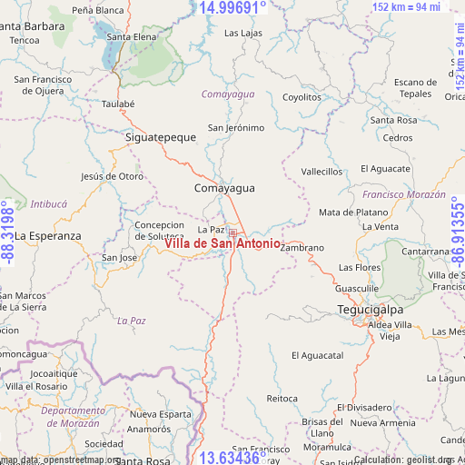
Villa de San Antonio GPS coordinates[2]
14° 19' 0.012" North, 87° 37' 0.012" West
| Map corner | latitude | longitude |
|---|---|---|
| Upper-left | 14.99691°, | -88.3198° |
| Center: | 14.31667°, | -87.61667° |
| Lower-right: | 13.63436°, | -86.91355° |
| Map W x H: | 151.5×151.5 km | = 94.1×94.1mi |
| max Lat: | 16.45° ⇑77% North |
| Villa de San Antonio: | 14.31667° |
| min Lat: | ⇓23% South 13.11667° |
| min Long | Villa de San An | max Long |
| -89.23333° | -87.61667° | -83.23333° |
| W 50.4%⇐ | ⇒49.6% E |
Elevation
Elevation of Villa de San Antonio is 596 m = 1955 ft, and this is 34.8 m = 114 ft above average elevation for this country.
| Max E: |
1811 m = 5942 ft | 47.2% |
| Villa de San Antonio | 596 m 1955 ft | |
| Avg. | 561.2 m = 1841 ft | |
Min E: |
1 m = 3 ft | 52.8% |
See also: Honduras elevation on elevation.city.
Geographical zone
Villa de San Antonio is located in North Torrid zone (between Equator and Tropic of Cancer). Distance of this Northern Tropic circle is 1014.1 km =630.1 mi to North.| Distance of | km | miles | from Villa de San Antonio |
|---|---|---|---|
| North Pole | 8415.2 | 5229 | to North |
| Arctic Circle | 5809.3 | 3609.7 | to North |
| Tropic Cancer | 1014.1 | 630.1 | to North |
| Equator | 1591.9 | 989.2 | to South |


Nearby cities:
15 places around Villa de San Antonio: (largest is in red/bold)
• Ajuterique
11.6 km =7.2 mi,  309°
309°
• Cane
6.5 km =4 mi,  235°
235°
• Comayagua
15.1 km =9.4 mi,  351°
351°
• El Sauce
24.1 km =15 mi, 347°
• Flores
6.5 km =4 mi,  124°
124°
• La Paz
6.7 km =4.2 mi,  272°
272°
• Lamaní
13 km =8.1 mi,  180°
180°
• Las Mercedes
6.5 km =4 mi, 124°
• Lejamaní
10.6 km =6.6 mi,  301°
301°
• Palo Pintado
23.4 km =14.5 mi,  342°
342°
• San Sebastián
7.6 km =4.7 mi,  193°
193°
• Tepanguare
14.5 km =9 mi,  277°
277°
• Valle de Ángeles
20.5 km =12.7 mi, 354°
• Yarumela
2.6 km =1.6 mi,  315°
315°
• Zambrano
24 km =14.9 mi,  103°
103°
Sources, notices
• [Note1] Compared only with cities in Honduras existing in our database
• [Src1] Map data: © OpenStreetMap contributors (CC-BY-SA)
• [Src2] Other city data from geonames.org with taken over terms of usage.
• [Src3] Geographical zone / Annual Mean Temperature by Robert A. Rohde @ Wikipedia
