Armenta geodata
Armenta (Cortés) is a populated place; located in Honduras in America/Tegucigalpa (GMT-6) time zone. With population of 2,989 people, there are 112 cities with bigger population in this country. Compared to other cities in Honduras, 84.6% of cities are located further ↓South; 70.6% of cities are located further →East and 72.6% of cities have higher elevation than Armenta. Note1


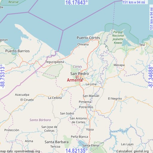
Armenta GPS coordinates[2]
15° 30' 0" North, 88° 3' 0" West
| Map corner | latitude | longitude |
|---|---|---|
| Upper-left | 16.17643°, | -88.75313° |
| Center: | 15.5°, | -88.05° |
| Lower-right: | 14.82135°, | -87.34688° |
| Map W x H: | 150.7×150.7 km | = 93.6×93.6mi |
| max Lat: | 16.45° ⇑15.4% North |
| Armenta: | 15.5° |
| min Lat: | ⇓84.6% South 13.11667° |
| min Long | Armenta | max Long |
| -89.23333° | -88.05° | -83.23333° |
| W 29.4%⇐ | ⇒70.6% E |
Elevation
Elevation of Armenta is 191 m = 627 ft, and this is 370.2 m = 1215 ft below average elevation for this country.
| Max E: |
1811 m = 5942 ft | 72.6% |
| Avg. | 561.2 m = 1841 ft | |
| Armenta | 191 m = 627 ft | |
Min E: |
1 m = 3 ft | 27.4% |
See also: Honduras elevation on elevation.city.
Geographical zone
Armenta is located in North Torrid zone (between Equator and Tropic of Cancer). Distance of this Northern Tropic circle is 882.5 km =548.4 mi to North.| Distance of | km | miles | from Armenta |
|---|---|---|---|
| North Pole | 8283.6 | 5147.2 | to North |
| Arctic Circle | 5677.7 | 3528 | to North |
| Tropic Cancer | 882.5 | 548.4 | to North |
| Equator | 1723.4 | 1070.9 | to South |


Nearby cities:
15 places around Armenta: (largest is in red/bold)
• Buenos Aires
14.4 km =8.9 mi,  262°
262°
• Choloma
16.4 km =10.2 mi,  39°
39°
• Chotepe
11.7 km =7.3 mi,  142°
142°
• Cofradía
15.4 km =9.6 mi,  223°
223°
• El Marañón
11.1 km =6.9 mi,  180°
180°
• El Milagro
14.3 km =8.9 mi, 141°
• El Zapotal del Norte
1.9 km =1.2 mi,  0°
0°
• La Esperanza
17 km =10.6 mi,  237°
237°
• La Jutosa
15.8 km =9.8 mi,  19°
19°
• La Lima
16.1 km =10 mi,  117°
117°
• Naco
19.3 km =12 mi,  227°
227°
• Nuevo Chamelecón
13.5 km =8.4 mi,  164°
164°
• Peña Blanca
3.7 km =2.3 mi, 0°
• San Pedro Sula
2.7 km =1.7 mi,  80°
80°
• Santa Elena
15.7 km =9.8 mi,  214°
214°
Sources, notices
• [Note1] Compared only with cities in Honduras existing in our database
• [Src1] Map data: © OpenStreetMap contributors (CC-BY-SA)
• [Src2] Other city data from geonames.org with taken over terms of usage.
• [Src3] Geographical zone / Annual Mean Temperature by Robert A. Rohde @ Wikipedia
