San Pedro Sula geodata
San Pedro Sula (Cortés) is a seat of a first-order administrative division; located in Honduras in America/Tegucigalpa (GMT-6) time zone. With population of 489,466 people, there is 1 city with bigger population in this country. Compared to other cities in Honduras, 85.4% of cities are located further ↓South; 68.8% of cities are located further →East and 79% of cities have higher elevation than San Pedro Sula. Note1


San Pedro Sula GPS coordinates[2]
15° 30' 15.012" North, 88° 1' 30" West
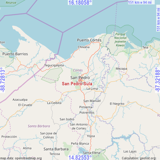
| Map corner | latitude | longitude |
|---|---|---|
| Upper-left | 16.18058°, | -88.72813° |
| Center: | 15.50417°, | -88.025° |
| Lower-right: | 14.82553°, | -87.32188° |
| Map W x H: | 150.7×150.7 km | = 93.6×93.6mi |
| max Lat: | 16.45° ⇑14.6% North |
| San Pedro Sula: | 15.50417° |
| min Lat: | ⇓85.4% South 13.11667° |
| min Long | San Pedro Sula | max Long |
| -89.23333° | -88.025° | -83.23333° |
| W 31.2%⇐ | ⇒68.8% E |
Elevation
Elevation of San Pedro Sula is 92 m = 302 ft, and this is 469.2 m = 1539 ft below average elevation for this country.
| Max E: |
1811 m = 5942 ft | 79% |
| Avg. | 561.2 m = 1841 ft | |
| San Pedro Sula | 92 m = 302 ft | |
Min E: |
1 m = 3 ft | 21% |
See also: San Pedro Sula elevation on elevation.city.
Geographical zone
San Pedro Sula is located in North Torrid zone (between Equator and Tropic of Cancer). Distance of this Northern Tropic circle is 882 km =548 mi to North.| Distance of | km | miles | from San Pedro Sula |
|---|---|---|---|
| North Pole | 8283.2 | 5146.9 | to North |
| Arctic Circle | 5677.3 | 3527.7 | to North |
| Tropic Cancer | 882 | 548 | to North |
| Equator | 1723.9 | 1071.2 | to South |


Nearby cities:
15 places around San Pedro Sula: (largest is in red/bold)
• Armenta
2.7 km =1.7 mi,  260°
260°
• Buenos Aires
17.1 km =10.6 mi, 262°
• Choloma
14.5 km =9 mi,  32°
32°
• Chotepe
10.7 km =6.6 mi,  155°
155°
• Cofradía
17.7 km =11 mi,  229°
229°
• El Marañón
11.9 km =7.4 mi,  193°
193°
• El Milagro
13.2 km =8.2 mi,  151°
151°
• El Zapotal del Norte
3 km =1.9 mi,  297°
297°
• La Huesa
17.5 km =10.9 mi,  59°
59°
• La Jutosa
14.6 km =9.1 mi,  10°
10°
• La Lima
14 km =8.7 mi,  124°
124°
• Monterrey
17.5 km =10.9 mi, 59°
• Nuevo Chamelecón
13.5 km =8.4 mi,  176°
176°
• Peña Blanca
4.2 km =2.6 mi,  320°
320°
• San José del Boquerón
17.1 km =10.6 mi,  97°
97°
Sources, notices
• [Note1] Compared only with cities in Honduras existing in our database
• [Src1] Map data: © OpenStreetMap contributors (CC-BY-SA)
• [Src2] Other city data from geonames.org with taken over terms of usage.
• [Src3] Geographical zone / Annual Mean Temperature by Robert A. Rohde @ Wikipedia
