La Lima geodata
La Lima (Cortés) is a populated place; located in Honduras in America/Tegucigalpa (GMT-6) time zone. With population of 45,955 people, there are 8 cities with bigger population in this country. Compared to other cities in Honduras, 81.6% of cities are located further ↓South; 61.4% of cities are located further →East and 87.6% of cities have higher elevation than La Lima. Note1


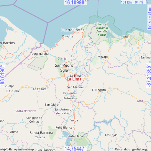
La Lima GPS coordinates[2]
15° 25' 59.988" North, 87° 55' 0.012" West
| Map corner | latitude | longitude |
|---|---|---|
| Upper-left | 16.10998°, | -88.6198° |
| Center: | 15.43333°, | -87.91667° |
| Lower-right: | 14.75447°, | -87.21355° |
| Map W x H: | 150.7×150.7 km | = 93.6×93.6mi |
| max Lat: | 16.45° ⇑18.4% North |
| La Lima: | 15.43333° |
| min Lat: | ⇓81.6% South 13.11667° |
| min Long | La Lima | max Long |
| -89.23333° | -87.91667° | -83.23333° |
| W 38.6%⇐ | ⇒61.4% E |
Elevation
Elevation of La Lima is 33 m = 108 ft, and this is 528.2 m = 1733 ft below average elevation for this country.
| Max E: |
1811 m = 5942 ft | 87.6% |
| Avg. | 561.2 m = 1841 ft | |
| La Lima | 33 m = 108 ft | |
Min E: |
1 m = 3 ft | 12.4% |
See also: La Lima elevation on elevation.city.
Geographical zone
La Lima is located in North Torrid zone (between Equator and Tropic of Cancer). Distance of this Northern Tropic circle is 889.9 km =553 mi to North.| Distance of | km | miles | from La Lima |
|---|---|---|---|
| North Pole | 8291 | 5151.8 | to North |
| Arctic Circle | 5685.1 | 3532.6 | to North |
| Tropic Cancer | 889.9 | 553 | to North |
| Equator | 1716 | 1066.3 | to South |


Nearby cities:
15 places around La Lima: (largest is in red/bold)
• Armenta
16.1 km =10 mi,  297°
297°
• Chotepe
7.4 km =4.6 mi,  255°
255°
• El Marañón
14.8 km =9.2 mi, 255°
• El Milagro
6.5 km =4 mi,  235°
235°
• El Progreso
13 km =8.1 mi,  106°
106°
• El Zapotal del Norte
17 km =10.6 mi, 302°
• La Mina
15.8 km =9.8 mi,  145°
145°
• La Sabana
7.6 km =4.7 mi,  193°
193°
• Nuevo Chamelecón
12.1 km =7.5 mi, 242°
• Quebrada de Yoro
14.3 km =8.9 mi,  90°
90°
• San José del Boquerón
7.7 km =4.8 mi,  43°
43°
• San Manuel
11.1 km =6.9 mi,  180°
180°
• San Pedro Sula
14 km =8.7 mi, 304°
• Victoria
12.5 km =7.8 mi,  51°
51°
• Villanueva
15.8 km =9.8 mi,  214°
214°
Sources, notices
• [Note1] Compared only with cities in Honduras existing in our database
• [Src1] Map data: © OpenStreetMap contributors (CC-BY-SA)
• [Src2] Other city data from geonames.org with taken over terms of usage.
• [Src3] Geographical zone / Annual Mean Temperature by Robert A. Rohde @ Wikipedia
