Las Trojes geodata
Las Trojes (El Paraíso) is a populated place; located in Honduras in America/Tegucigalpa (GMT-6) time zone. With population of 6,253 people, there are 52 cities with bigger population in this country. Compared to other cities in Honduras, 85% of cities are located further ↑North; 93.4% of cities are located further ←West and 68.2% of cities have lower elevation than Las Trojes. Note1


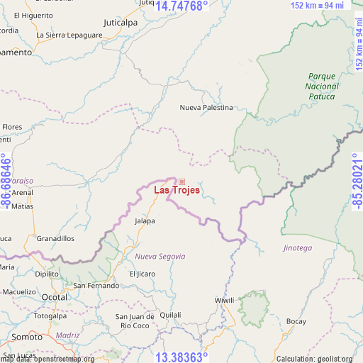
Las Trojes GPS coordinates[2]
14° 4' 0.012" North, 85° 58' 59.988" West
| Map corner | latitude | longitude |
|---|---|---|
| Upper-left | 14.74768°, | -86.68646° |
| Center: | 14.06667°, | -85.98333° |
| Lower-right: | 13.38363°, | -85.28021° |
| Map W x H: | 151.7×151.7 km | = 94.3×94.3mi |
| max Lat: | 16.45° ⇑85% North |
| Las Trojes: | 14.06667° |
| min Lat: | ⇓15% South 13.11667° |
| min Long | Las Trojes | max Long |
| -89.23333° | -85.98333° | -83.23333° |
| W 93.4%⇐ | ⇒6.6% E |
Elevation
Elevation of Las Trojes is 755 m = 2477 ft, and this is 193.8 m = 636 ft above average elevation for this country.
| Max E: |
1811 m = 5942 ft | 31.8% |
| Las Trojes | 755 m 2477 ft | |
| Avg. | 561.2 m = 1841 ft | |
Min E: |
1 m = 3 ft | 68.2% |
See also: Honduras elevation on elevation.city.
Geographical zone
Las Trojes is located in North Torrid zone (between Equator and Tropic of Cancer). Distance of this Northern Tropic circle is 1041.9 km =647.4 mi to North.| Distance of | km | miles | from Las Trojes |
|---|---|---|---|
| North Pole | 8443 | 5246.2 | to North |
| Arctic Circle | 5837.1 | 3627 | to North |
| Tropic Cancer | 1041.9 | 647.4 | to North |
| Equator | 1564.1 | 971.9 | to South |


Nearby cities:
15 places around Las Trojes: (largest is in red/bold)
• Araulí
62.5 km =38.8 mi,  258°
258°
• Cuyalí
64.5 km =40.1 mi,  251°
251°
• Danlí
64.8 km =40.3 mi,  266°
266°
• El Benque
52.3 km =32.5 mi, 265°
• El Chichicaste
34.2 km =21.3 mi, 270°
• El Obraje
49.1 km =30.5 mi, 261°
• El Paraíso
65.1 km =40.5 mi, 250°
• El Pescadero
62.9 km =39.1 mi, 256°
• El Rusio
60.7 km =37.7 mi,  317°
317°
• Jutiapa
45.9 km =28.5 mi, 258°
• Ojo de Agua
39.9 km =24.8 mi, 261°
• Quebrada Larga
41.5 km =25.8 mi,  275°
275°
• San Diego
52.2 km =32.4 mi, 267°
• San Francisco de Becerra
64.2 km =39.9 mi,  348°
348°
• San Nicolás
60.9 km =37.8 mi,  331°
331°
Sources, notices
• [Note1] Compared only with cities in Honduras existing in our database
• [Src1] Map data: © OpenStreetMap contributors (CC-BY-SA)
• [Src2] Other city data from geonames.org with taken over terms of usage.
• [Src3] Geographical zone / Annual Mean Temperature by Robert A. Rohde @ Wikipedia
