El Obraje geodata
El Obraje (El Paraíso) is a populated place; located in Honduras in America/Tegucigalpa (GMT-6) time zone. With population of 1,703 people, there are 215 cities with bigger population in this country. Compared to other cities in Honduras, 87.6% of cities are located further ↑North; 86.4% of cities are located further ←West and 52.6% of cities have higher elevation than El Obraje. Note1


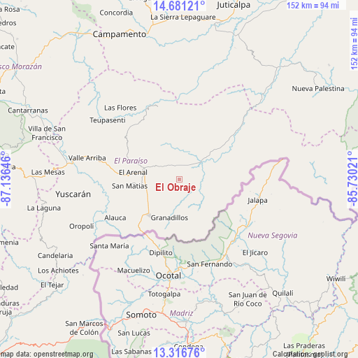
El Obraje GPS coordinates[2]
14° 0' 0" North, 86° 25' 59.988" West
| Map corner | latitude | longitude |
|---|---|---|
| Upper-left | 14.68121°, | -87.13646° |
| Center: | 14°, | -86.43333° |
| Lower-right: | 13.31676°, | -85.73021° |
| Map W x H: | 151.7×151.7 km | = 94.3×94.3mi |
| max Lat: | 16.45° ⇑87.6% North |
| El Obraje: | 14° |
| min Lat: | ⇓12.4% South 13.11667° |
| min Long | El Obraje | max Long |
| -89.23333° | -86.43333° | -83.23333° |
| W 86.4%⇐ | ⇒13.6% E |
Elevation
Elevation of El Obraje is 527 m = 1729 ft, and this is 34.2 m = 112 ft below average elevation for this country.
| Max E: |
1811 m = 5942 ft | 52.6% |
| Avg. | 561.2 m = 1841 ft | |
| El Obraje | 527 m = 1729 ft | |
Min E: |
1 m = 3 ft | 47.4% |
See also: Honduras elevation on elevation.city.
Geographical zone
El Obraje is located in North Torrid zone (between Equator and Tropic of Cancer). Distance of this Northern Tropic circle is 1049.3 km =652 mi to North.| Distance of | km | miles | from El Obraje |
|---|---|---|---|
| North Pole | 8450.4 | 5250.8 | to North |
| Arctic Circle | 5844.5 | 3631.6 | to North |
| Tropic Cancer | 1049.3 | 652 | to North |
| Equator | 1556.7 | 967.3 | to South |


Nearby cities:
15 places around El Obraje: (largest is in red/bold)
• Araulí
13.8 km =8.6 mi,  246°
246°
• Cuyalí
18.1 km =11.2 mi,  224°
224°
• Danlí
16.6 km =10.3 mi,  282°
282°
• El Benque
5.2 km =3.2 mi,  315°
315°
• El Chichicaste
16.2 km =10.1 mi,  62°
62°
• El Paraíso
19.5 km =12.1 mi, 220°
• El Pescadero
14.6 km =9.1 mi,  239°
239°
• Jacaleapa
25.2 km =15.7 mi,  274°
274°
• Jutiapa
4 km =2.5 mi,  117°
117°
• Las Ánimas
31.3 km =19.4 mi,  332°
332°
• Ojo de Agua
9.2 km =5.7 mi,  78°
78°
• Quebrada Larga
13.2 km =8.2 mi,  32°
32°
• San Diego
6.6 km =4.1 mi, 327°
• San Matías
21.7 km =13.5 mi, 265°
• Santa Cruz
26.2 km =16.3 mi, 235°
Sources, notices
• [Note1] Compared only with cities in Honduras existing in our database
• [Src1] Map data: © OpenStreetMap contributors (CC-BY-SA)
• [Src2] Other city data from geonames.org with taken over terms of usage.
• [Src3] Geographical zone / Annual Mean Temperature by Robert A. Rohde @ Wikipedia
