El Benque geodata
El Benque (El Paraíso) is a populated place; located in Honduras in America/Tegucigalpa (GMT-6) time zone. With population of 1,101 people, there are 360 cities with bigger population in this country. Compared to other cities in Honduras, 86.4% of cities are located further ↑North; 86% of cities are located further ←West and 50.4% of cities have higher elevation than El Benque. Note1


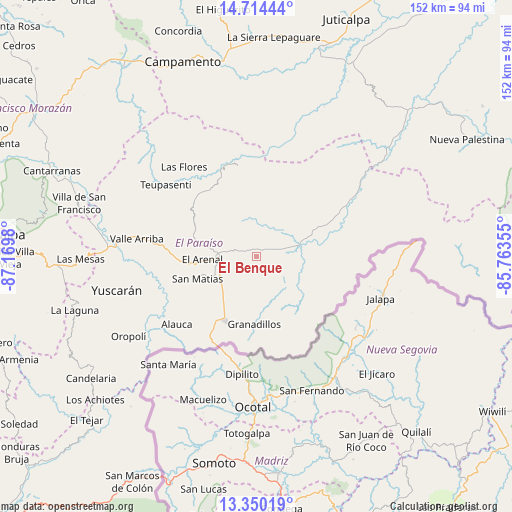
El Benque GPS coordinates[2]
14° 1' 59.988" North, 86° 28' 0.012" West
| Map corner | latitude | longitude |
|---|---|---|
| Upper-left | 14.71444°, | -87.1698° |
| Center: | 14.03333°, | -86.46667° |
| Lower-right: | 13.35019°, | -85.76355° |
| Map W x H: | 151.7×151.7 km | = 94.3×94.3mi |
| max Lat: | 16.45° ⇑86.4% North |
| El Benque: | 14.03333° |
| min Lat: | ⇓13.6% South 13.11667° |
| min Long | El Benque | max Long |
| -89.23333° | -86.46667° | -83.23333° |
| W 86%⇐ | ⇒14% E |
Elevation
Elevation of El Benque is 563 m = 1847 ft, and this is 1.8 m = 6 ft above average elevation for this country.
| Max E: |
1811 m = 5942 ft | 50.4% |
| El Benque | 563 m 1847 ft | |
| Avg. | 561.2 m = 1841 ft | |
Min E: |
1 m = 3 ft | 49.6% |
See also: Honduras elevation on elevation.city.
Geographical zone
El Benque is located in North Torrid zone (between Equator and Tropic of Cancer). Distance of this Northern Tropic circle is 1045.6 km =649.7 mi to North.| Distance of | km | miles | from El Benque |
|---|---|---|---|
| North Pole | 8446.7 | 5248.5 | to North |
| Arctic Circle | 5840.8 | 3629.3 | to North |
| Tropic Cancer | 1045.6 | 649.7 | to North |
| Equator | 1560.4 | 969.6 | to South |


Nearby cities:
15 places around El Benque: (largest is in red/bold)
• Araulí
12.9 km =8 mi,  224°
224°
• Cuyalí
18.9 km =11.7 mi,  208°
208°
• Danlí
12.6 km =7.8 mi,  270°
270°
• El Chichicaste
18.4 km =11.4 mi,  78°
78°
• El Obraje
5.2 km =3.2 mi,  135°
135°
• El Paraíso
20.6 km =12.8 mi, 205°
• El Pescadero
14.3 km =8.9 mi, 218°
• Jacaleapa
21.7 km =13.5 mi, 265°
• Jutiapa
9.1 km =5.7 mi,  127°
127°
• Las Ánimas
26.4 km =16.4 mi,  335°
335°
• Ojo de Agua
12.7 km =7.9 mi,  98°
98°
• Quebrada Larga
13.1 km =8.1 mi,  55°
55°
• San Diego
1.9 km =1.2 mi,  0°
0°
• San Matías
18.8 km =11.7 mi,  252°
252°
• Santa Cruz
25.8 km =16 mi, 224°
Sources, notices
• [Note1] Compared only with cities in Honduras existing in our database
• [Src1] Map data: © OpenStreetMap contributors (CC-BY-SA)
• [Src2] Other city data from geonames.org with taken over terms of usage.
• [Src3] Geographical zone / Annual Mean Temperature by Robert A. Rohde @ Wikipedia
