El Chichicaste geodata
El Chichicaste (El Paraíso) is a populated place; located in Honduras in America/Tegucigalpa (GMT-6) time zone. With population of 1,671 people, there are 221 cities with bigger population in this country. Compared to other cities in Honduras, 85% of cities are located further ↑North; 89.6% of cities are located further ←West and 59.6% of cities have higher elevation than El Chichicaste. Note1


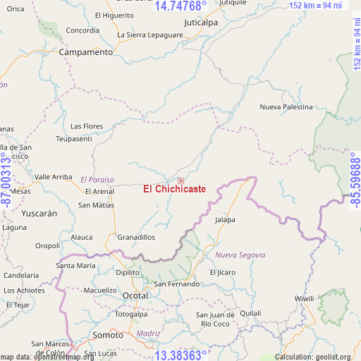
El Chichicaste GPS coordinates[2]
14° 4' 0.012" North, 86° 18' 0" West
| Map corner | latitude | longitude |
|---|---|---|
| Upper-left | 14.74768°, | -87.00313° |
| Center: | 14.06667°, | -86.3° |
| Lower-right: | 13.38363°, | -85.59688° |
| Map W x H: | 151.7×151.7 km | = 94.3×94.3mi |
| max Lat: | 16.45° ⇑85% North |
| El Chichicaste: | 14.06667° |
| min Lat: | ⇓15% South 13.11667° |
| min Long | El Chichicaste | max Long |
| -89.23333° | -86.3° | -83.23333° |
| W 89.6%⇐ | ⇒10.4% E |
Elevation
Elevation of El Chichicaste is 413 m = 1355 ft, and this is 148.2 m = 486 ft below average elevation for this country.
| Max E: |
1811 m = 5942 ft | 59.6% |
| Avg. | 561.2 m = 1841 ft | |
| El Chichicaste | 413 m = 1355 ft | |
Min E: |
1 m = 3 ft | 40.4% |
See also: Honduras elevation on elevation.city.
Geographical zone
El Chichicaste is located in North Torrid zone (between Equator and Tropic of Cancer). Distance of this Northern Tropic circle is 1041.9 km =647.4 mi to North.| Distance of | km | miles | from El Chichicaste |
|---|---|---|---|
| North Pole | 8443 | 5246.2 | to North |
| Arctic Circle | 5837.1 | 3627 | to North |
| Tropic Cancer | 1041.9 | 647.4 | to North |
| Equator | 1564.1 | 971.9 | to South |


Nearby cities:
15 places around El Chichicaste: (largest is in red/bold)
• Araulí
29.9 km =18.6 mi,  244°
244°
• Cuyalí
33.8 km =21 mi,  232°
232°
• Danlí
30.8 km =19.1 mi,  263°
263°
• El Benque
18.4 km =11.4 mi, 258°
• El Obraje
16.2 km =10.1 mi, 242°
• El Paraíso
35 km =21.7 mi, 230°
• El Pescadero
30.8 km =19.1 mi, 241°
• Jacaleapa
39.9 km =24.8 mi, 261°
• Jutiapa
14.2 km =8.8 mi, 229°
• Las Trojes
34.2 km =21.3 mi,  90°
90°
• Las Ánimas
35.2 km =21.9 mi,  305°
305°
• Ojo de Agua
7.7 km =4.8 mi,  224°
224°
• Quebrada Larga
8.1 km =5 mi,  297°
297°
• San Diego
18.1 km =11.2 mi, 264°
• San Matías
37.1 km =23.1 mi, 255°
Sources, notices
• [Note1] Compared only with cities in Honduras existing in our database
• [Src1] Map data: © OpenStreetMap contributors (CC-BY-SA)
• [Src2] Other city data from geonames.org with taken over terms of usage.
• [Src3] Geographical zone / Annual Mean Temperature by Robert A. Rohde @ Wikipedia
