Guacamaya geodata
Guacamaya (Santa Bárbara) is a populated place; located in Honduras in America/Tegucigalpa (GMT-6) time zone. With population of 1,250 people, there are 307 cities with bigger population in this country. Compared to other cities in Honduras, 57.8% of cities are located further ↓South; 73.2% of cities are located further →East and 60% of cities have lower elevation than Guacamaya. Note1


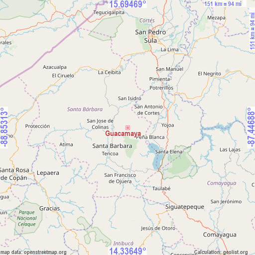
Guacamaya GPS coordinates[2]
15° 1' 0.012" North, 88° 9' 0" West
| Map corner | latitude | longitude |
|---|---|---|
| Upper-left | 15.69469°, | -88.85313° |
| Center: | 15.01667°, | -88.15° |
| Lower-right: | 14.33649°, | -87.44688° |
| Map W x H: | 151×151 km | = 93.8×93.8mi |
| max Lat: | 16.45° ⇑42.2% North |
| Guacamaya: | 15.01667° |
| min Lat: | ⇓57.8% South 13.11667° |
| min Long | Guacamaya | max Long |
| -89.23333° | -88.15° | -83.23333° |
| W 26.8%⇐ | ⇒73.2% E |
Elevation
Elevation of Guacamaya is 673 m = 2208 ft, and this is 111.8 m = 367 ft above average elevation for this country.
| Max E: |
1811 m = 5942 ft | 40% |
| Guacamaya | 673 m 2208 ft | |
| Avg. | 561.2 m = 1841 ft | |
Min E: |
1 m = 3 ft | 60% |
See also: Honduras elevation on elevation.city.
Geographical zone
Guacamaya is located in North Torrid zone (between Equator and Tropic of Cancer). Distance of this Northern Tropic circle is 936.2 km =581.7 mi to North.| Distance of | km | miles | from Guacamaya |
|---|---|---|---|
| North Pole | 8337.4 | 5180.6 | to North |
| Arctic Circle | 5731.5 | 3561.4 | to North |
| Tropic Cancer | 936.2 | 581.7 | to North |
| Equator | 1669.7 | 1037.5 | to South |


Nearby cities:
15 places around Guacamaya: (largest is in red/bold)
• Casa Quemada
13.2 km =8.2 mi,  32°
32°
• Cañaveral
14.8 km =9.2 mi,  104°
104°
• El Edén
16.1 km =10 mi,  117°
117°
• El Perico
9.2 km =5.7 mi,  35°
35°
• Gualjoco
11.6 km =7.2 mi,  230°
230°
• Ilama
9.1 km =5.7 mi,  307°
307°
• Nueva Granada
12.3 km =7.6 mi, 25°
• San Antonio de Cortés
16.7 km =10.4 mi,  48°
48°
• San Buenaventura
16.1 km =10 mi,  90°
90°
• San José de Colinas
16.2 km =10.1 mi,  276°
276°
• San José de Oriente
4 km =2.5 mi,  62°
62°
• San Luis de Planes
4.1 km =2.5 mi,  154°
154°
• Santa Bárbara
14.2 km =8.8 mi,  220°
220°
• Santa Rita
13.2 km =8.2 mi,  212°
212°
• Trinidad
15.8 km =9.8 mi,  325°
325°
Sources, notices
• [Note1] Compared only with cities in Honduras existing in our database
• [Src1] Map data: © OpenStreetMap contributors (CC-BY-SA)
• [Src2] Other city data from geonames.org with taken over terms of usage.
• [Src3] Geographical zone / Annual Mean Temperature by Robert A. Rohde @ Wikipedia
