Gracias geodata
Gracias (Lempira) is a seat of a first-order administrative division; located in Honduras in America/Tegucigalpa (GMT-6) time zone. With population of 7,909 people, there are 40 cities with bigger population in this country. Compared to other cities in Honduras, 67% of cities are located further ↑North; 84.4% of cities are located further →East and 72.8% of cities have lower elevation than Gracias. Note1


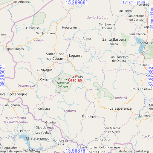
Gracias GPS coordinates[2]
14° 35' 25.008" North, 88° 34' 54.984" West
| Map corner | latitude | longitude |
|---|---|---|
| Upper-left | 15.26966°, | -89.28507° |
| Center: | 14.59028°, | -88.58194° |
| Lower-right: | 13.90879°, | -87.87882° |
| Map W x H: | 151.3×151.3 km | = 94×94mi |
| max Lat: | 16.45° ⇑67% North |
| Gracias: | 14.59028° |
| min Lat: | ⇓33% South 13.11667° |
| min Long | Gracias | max Long |
| -89.23333° | -88.58194° | -83.23333° |
| W 15.6%⇐ | ⇒84.4% E |
Elevation
Elevation of Gracias is 798 m = 2618 ft, and this is 236.8 m = 777 ft above average elevation for this country.
| Max E: |
1811 m = 5942 ft | 27.2% |
| Gracias | 798 m 2618 ft | |
| Avg. | 561.2 m = 1841 ft | |
Min E: |
1 m = 3 ft | 72.8% |
See also: Honduras elevation on elevation.city.
Geographical zone
Gracias is located in North Torrid zone (between Equator and Tropic of Cancer). Distance of this Northern Tropic circle is 983.6 km =611.2 mi to North.| Distance of | km | miles | from Gracias |
|---|---|---|---|
| North Pole | 8384.8 | 5210.1 | to North |
| Arctic Circle | 5778.9 | 3590.8 | to North |
| Tropic Cancer | 983.6 | 611.2 | to North |
| Equator | 1622.3 | 1008.1 | to South |


Nearby cities:
15 places around Gracias: (largest is in red/bold)
• Belén Gualcho
26.3 km =16.3 mi,  243°
243°
• Berlín
28.4 km =17.6 mi,  18°
18°
• Corquín
30.8 km =19.1 mi,  265°
265°
• Cucuyagua
31.3 km =19.4 mi,  282°
282°
• El Derrumbo
28 km =17.4 mi,  309°
309°
• La Laguna del Pedernal
25.2 km =15.7 mi,  3°
3°
• La Libertad
23.3 km =14.5 mi,  359°
359°
• Lagunas
11 km =6.8 mi,  74°
74°
• Las Tejeras
23.4 km =14.5 mi, 355°
• Lepaera
21.5 km =13.4 mi, 359°
• Ojos de Agua
28 km =17.4 mi,  295°
295°
• San Juan de Opoa
24.9 km =15.5 mi,  329°
329°
• Santa Rosa de Copán
28.9 km =18 mi, 312°
• Taragual
20.7 km =12.9 mi,  30°
30°
• Yaruchel
26 km =16.2 mi,  255°
255°
Sources, notices
• [Note1] Compared only with cities in Honduras existing in our database
• [Src1] Map data: © OpenStreetMap contributors (CC-BY-SA)
• [Src2] Other city data from geonames.org with taken over terms of usage.
• [Src3] Geographical zone / Annual Mean Temperature by Robert A. Rohde @ Wikipedia
