La Trinidad geodata
La Trinidad (Comayagua) is a populated place; located in Honduras in America/Tegucigalpa (GMT-6) time zone. With population of 880 people, there are 489 cities with bigger population in this country. Compared to other cities in Honduras, 60% of cities are located further ↑North; 52.2% of cities are located further →East and 51.4% of cities have higher elevation than La Trinidad. Note1


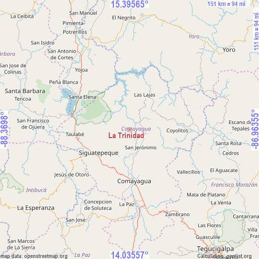
La Trinidad GPS coordinates[2]
14° 43' 0.012" North, 87° 40' 0.012" West
| Map corner | latitude | longitude |
|---|---|---|
| Upper-left | 15.39565°, | -88.3698° |
| Center: | 14.71667°, | -87.66667° |
| Lower-right: | 14.03557°, | -86.96355° |
| Map W x H: | 151.2×151.2 km | = 94×94mi |
| max Lat: | 16.45° ⇑60% North |
| La Trinidad: | 14.71667° |
| min Lat: | ⇓40% South 13.11667° |
| min Long | La Trinidad | max Long |
| -89.23333° | -87.66667° | -83.23333° |
| W 47.8%⇐ | ⇒52.2% E |
Elevation
Elevation of La Trinidad is 548 m = 1798 ft, and this is 13.2 m = 43 ft below average elevation for this country.
| Max E: |
1811 m = 5942 ft | 51.4% |
| Avg. | 561.2 m = 1841 ft | |
| La Trinidad | 548 m = 1798 ft | |
Min E: |
1 m = 3 ft | 48.6% |
See also: Honduras elevation on elevation.city.
Geographical zone
La Trinidad is located in North Torrid zone (between Equator and Tropic of Cancer). Distance of this Northern Tropic circle is 969.6 km =602.5 mi to North.| Distance of | km | miles | from La Trinidad |
|---|---|---|---|
| North Pole | 8370.7 | 5201.3 | to North |
| Arctic Circle | 5764.8 | 3582.1 | to North |
| Tropic Cancer | 969.6 | 602.5 | to North |
| Equator | 1636.3 | 1016.7 | to South |


Nearby cities:
15 places around La Trinidad: (largest is in red/bold)
• Cerro Blanco
13.7 km =8.5 mi,  246°
246°
• Concepción de Guasistagua
13.1 km =8.1 mi,  172°
172°
• El Agua Dulcita
9.2 km =5.7 mi,  258°
258°
• El Buen Pastor
20.9 km =13 mi,  323°
323°
• El Rancho
18.3 km =11.4 mi,  101°
101°
• El Rosario
14.2 km =8.8 mi,  310°
310°
• El Sauce
20.9 km =13 mi,  179°
179°
• Jamalteca
9.2 km =5.7 mi, 101°
• La Libertad
6.5 km =4 mi,  55°
55°
• Las Lajas
11.6 km =7.2 mi, 309°
• Meámbar
13.1 km =8.1 mi,  304°
304°
• Palo Pintado
22.3 km =13.9 mi, 184°
• San Antonio de la Cuesta
11.7 km =7.3 mi,  142°
142°
• San Jerónimo
11.7 km =7.3 mi, 142°
• Siguatepeque
22.1 km =13.7 mi,  234°
234°
Sources, notices
• [Note1] Compared only with cities in Honduras existing in our database
• [Src1] Map data: © OpenStreetMap contributors (CC-BY-SA)
• [Src2] Other city data from geonames.org with taken over terms of usage.
• [Src3] Geographical zone / Annual Mean Temperature by Robert A. Rohde @ Wikipedia
