El Escaño de Tepale geodata
El Escaño de Tepale (Francisco Morazán) is a populated place; located in Honduras in America/Tegucigalpa (GMT-6) time zone. With population of 1,026 people, there are 406 cities with bigger population in this country. Compared to other cities in Honduras, 58.4% of cities are located further ↑North; 72% of cities are located further ←West and 68.4% of cities have lower elevation than El Escaño de Tepale. Note1


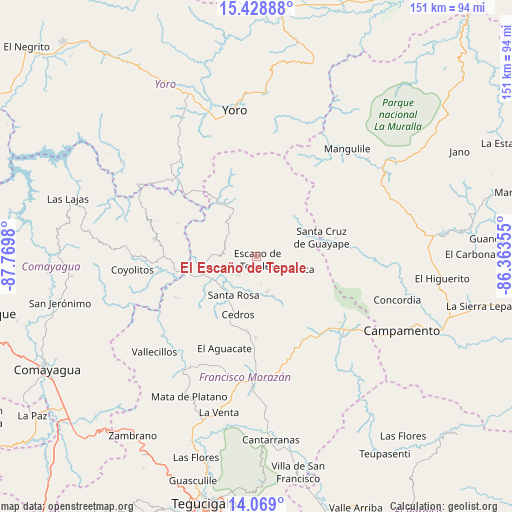
El Escaño de Tepale GPS coordinates[2]
14° 45' 0" North, 87° 4' 0.012" West
| Map corner | latitude | longitude |
|---|---|---|
| Upper-left | 15.42888°, | -87.7698° |
| Center: | 14.75°, | -87.06667° |
| Lower-right: | 14.069°, | -86.36355° |
| Map W x H: | 151.2×151.2 km | = 94×94mi |
| max Lat: | 16.45° ⇑58.4% North |
| El Escaño de Tepale: | 14.75° |
| min Lat: | ⇓41.6% South 13.11667° |
| min Long | El Escaño de T | max Long |
| -89.23333° | -87.06667° | -83.23333° |
| W 72%⇐ | ⇒28% E |
Elevation
Elevation of El Escaño de Tepale is 757 m = 2484 ft, and this is 195.8 m = 642 ft above average elevation for this country.
| Max E: |
1811 m = 5942 ft | 31.6% |
| El Escaño de Tepale | 757 m 2484 ft | |
| Avg. | 561.2 m = 1841 ft | |
Min E: |
1 m = 3 ft | 68.4% |
See also: Honduras elevation on elevation.city.
Geographical zone
El Escaño de Tepale is located in North Torrid zone (between Equator and Tropic of Cancer). Distance of this Northern Tropic circle is 965.9 km =600.2 mi to North.| Distance of | km | miles | from El Escaño de Tepale |
|---|---|---|---|
| North Pole | 8367 | 5199 | to North |
| Arctic Circle | 5761.1 | 3579.8 | to North |
| Tropic Cancer | 965.9 | 600.2 | to North |
| Equator | 1640 | 1019 | to South |


Nearby cities:
15 places around El Escaño de Tepale: (largest is in red/bold)
• Cedros
17.5 km =10.9 mi,  197°
197°
• El Escanito
9.9 km =6.2 mi, 201°
• El Guante
22.5 km =14 mi,  189°
189°
• El Guantillo
30.1 km =18.7 mi,  236°
236°
• El Pedernal
7.7 km =4.8 mi,  224°
224°
• El Suyatal
30.6 km =19 mi,  211°
211°
• Guayape
25.4 km =15.8 mi,  98°
98°
• Marale
17.3 km =10.7 mi,  328°
328°
• Mata de Plátano
28.7 km =17.8 mi,  234°
234°
• Orica
13.7 km =8.5 mi,  113°
113°
• San Ignacio
11.7 km =7.3 mi,  162°
162°
• San José del Potrero
25.1 km =15.6 mi,  291°
291°
• San Nicolás
30.7 km =19.1 mi,  263°
263°
• Sulaco
28.4 km =17.6 mi,  310°
310°
• Urrutia
3.6 km =2.2 mi,  90°
90°
Sources, notices
• [Note1] Compared only with cities in Honduras existing in our database
• [Src1] Map data: © OpenStreetMap contributors (CC-BY-SA)
• [Src2] Other city data from geonames.org with taken over terms of usage.
• [Src3] Geographical zone / Annual Mean Temperature by Robert A. Rohde @ Wikipedia
