Zbelava geodata
Zbelava (Varaždinska) is a populated place; located in Croatia in Europe/Zagreb (GMT+2) time zone. With population of 504 people, there are 881 cities with bigger population in this country. Compared to other cities in Croatia, 92.2% of cities are located further ↓South; 52.3% of cities are located further →East and 68.6% of cities have lower elevation than Zbelava. Note1


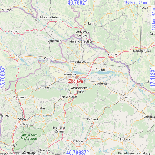
Zbelava GPS coordinates[2]
46° 17' 3.984" North, 16° 24' 33.012" East
| Map corner | latitude | longitude |
|---|---|---|
| Upper-left | 46.7682°, | 15.70605° |
| Center: | 46.28444°, | 16.40917° |
| Lower-right: | 45.79637°, | 17.1123° |
| Map W x H: | 108.1×108.1 km | = 67.2×67.2mi |
| max Lat: | 46.52694° ⇑7.8% North |
| Zbelava: | 46.28444° |
| min Lat: | ⇓92.2% South 42.54972° |
| min Long | Zbelava | max Long |
| 13.52389° | 16.40917° | 19.37694° |
| W 47.7%⇐ | ⇒52.3% E |
Elevation
Elevation of Zbelava is 164 m = 538 ft, and this is 10.7 m = 35 ft above average elevation for this country.
| Max E: |
827 m = 2713 ft | 31.4% |
| Zbelava | 164 m 538 ft | |
| Avg. | 153.3 m = 503 ft | |
Min E: |
-1 m = -3 ft | 68.6% |
See also: Croatia elevation on elevation.city.
Geographical zone
Zbelava is located in North temperate zone (between Tropic of Cancer and the Arctic Circle). Distance of this North polar circle is 2254.8 km =1401.1 mi to North.| Distance of | km | miles | from Zbelava |
|---|---|---|---|
| North Pole | 4860.7 | 3020.3 | to North |
| Arctic Circle | 2254.8 | 1401.1 | to North |
| Tropic Cancer | 2540.4 | 1578.5 | to South |
| Equator | 5146.3 | 3197.8 | to South |


Nearby cities:
15 places around Zbelava: (largest is in red/bold)
• Bartolovec
2.9 km =1.8 mi,  58°
58°
• Donji Kneginec
3.4 km =2.1 mi,  214°
214°
• Donji Kućan
1.3 km =0.8 mi,  248°
248°
• Gornji Kneginec
4.6 km =2.9 mi, 214°
• Jalžabet
5.7 km =3.5 mi,  117°
117°
• Kelemen
3.7 km =2.3 mi,  146°
146°
• Kuršanec
5.1 km =3.2 mi,  353°
353°
• Kućan Marof
2.9 km =1.8 mi,  281°
281°
• Novo Selo na Dravi
5.5 km =3.4 mi,  19°
19°
• Totovec
6.7 km =4.2 mi, 22°
• Trnovec Bartolovečki
1.4 km =0.9 mi,  325°
325°
• Turčin
4.7 km =2.9 mi,  234°
234°
• Varaždin
5.9 km =3.7 mi,  292°
292°
• Črnec Biškupečki
5 km =3.1 mi, 246°
• Šemovec
5.2 km =3.2 mi,  65°
65°
Sources, notices
• [Note1] Compared only with cities in Croatia existing in our database
• [Src1] Map data: © OpenStreetMap contributors (CC-BY-SA)
• [Src2] Other city data from geonames.org with taken over terms of usage.
• [Src3] Geographical zone / Annual Mean Temperature by Robert A. Rohde @ Wikipedia
