Vis geodata
Vis (Split-Dalmatia) is a seat of a second-order administrative division; located in Croatia in Europe/Zagreb (GMT+2) time zone. With population of 1,785 people, there are 243 cities with bigger population in this country. Compared to other cities in Croatia, 96.5% of cities are located further ↑North; 62.3% of cities are located further →East and 97.7% of cities have higher elevation than Vis. Note1


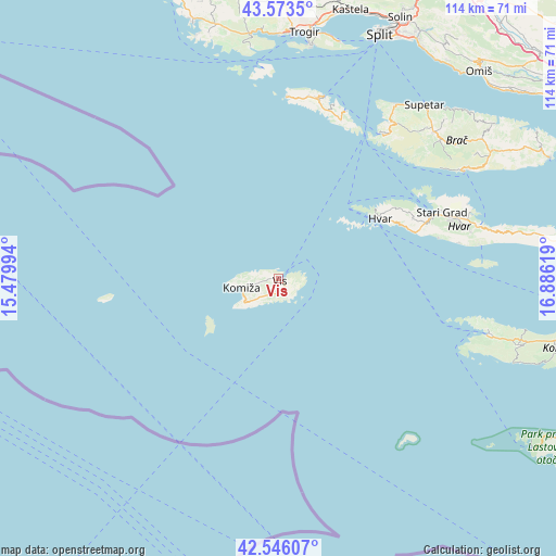
Vis GPS coordinates[2]
43° 3' 42.984" North, 16° 10' 59.016" East
| Map corner | latitude | longitude |
|---|---|---|
| Upper-left | 43.5735°, | 15.47994° |
| Center: | 43.06194°, | 16.18306° |
| Lower-right: | 42.54607°, | 16.88619° |
| Map W x H: | 114.2×114.2 km | = 71×71mi |
| max Lat: | 46.52694° ⇑96.5% North |
| Vis: | 43.06194° |
| min Lat: | ⇓3.5% South 42.54972° |
| min Long | Vis | max Long |
| 13.52389° | 16.18306° | 19.37694° |
| W 37.7%⇐ | ⇒62.3% E |
Elevation
Elevation of Vis is 5 m = 16 ft, and this is 148.3 m = 487 ft below average elevation for this country.
| Max E: |
827 m = 2713 ft | 97.7% |
| Avg. | 153.3 m = 503 ft | |
| Vis | 5 m = 16 ft | |
Min E: |
-1 m = -3 ft | 2.3% |
See also: Croatia elevation on elevation.city.
Geographical zone
Vis is located in North temperate zone (between Tropic of Cancer and the Arctic Circle). Distance of this Northern Tropic circle is 2182.1 km =1355.9 mi to South.| Distance of | km | miles | from Vis |
|---|---|---|---|
| North Pole | 5219 | 3242.9 | to North |
| Arctic Circle | 2613.1 | 1623.7 | to North |
| Tropic Cancer | 2182.1 | 1355.9 | to South |
| Equator | 4788 | 2975.1 | to South |


Nearby cities:
15 places around Vis: (largest is in red/bold)
• Bol
44.3 km =27.5 mi,  59°
59°
• Hvar
24.4 km =15.2 mi, 59°
• Jelsa
42.8 km =26.6 mi,  75°
75°
• Komiža
7.6 km =4.7 mi,  253°
253°
• Marina
38.7 km =24 mi,  34°
34°
• Milna
36.6 km =22.7 mi,  36°
36°
• Nerežišće
43.9 km =27.3 mi,  46°
46°
• Okrug Gornji
48.6 km =30.2 mi,  7°
7°
• Stari Grad
36.1 km =22.4 mi,  67°
67°
• Supetar
46.6 km =29 mi, 39°
• Sutivan
43.2 km =26.8 mi, 33°
• Vela Luka
45.2 km =28.1 mi,  104°
104°
• Veliki Drvenik
43.2 km =26.8 mi,  356°
356°
• Vinišće
47.9 km =29.8 mi,  353°
353°
• Vrboska
41.8 km =26 mi, 71°
Sources, notices
• [Note1] Compared only with cities in Croatia existing in our database
• [Src1] Map data: © OpenStreetMap contributors (CC-BY-SA)
• [Src2] Other city data from geonames.org with taken over terms of usage.
• [Src3] Geographical zone / Annual Mean Temperature by Robert A. Rohde @ Wikipedia
