Vela Luka geodata
Vela Luka (Dubrovačko-Neretvanska) is a seat of a second-order administrative division; located in Croatia in Europe/Zagreb (GMT+2) time zone. With population of 4,380 people, there are 90 cities with bigger population in this country. Compared to other cities in Croatia, 97.6% of cities are located further ↑North; 60.7% of cities are located further ←West and 85.3% of cities have higher elevation than Vela Luka. Note1


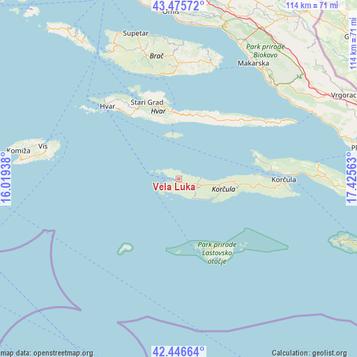
Vela Luka GPS coordinates[2]
42° 57' 47.988" North, 16° 43' 21" East
| Map corner | latitude | longitude |
|---|---|---|
| Upper-left | 43.47572°, | 16.01938° |
| Center: | 42.96333°, | 16.7225° |
| Lower-right: | 42.44664°, | 17.42563° |
| Map W x H: | 114.4×114.4 km | = 71.1×71.1mi |
| max Lat: | 46.52694° ⇑97.6% North |
| Vela Luka: | 42.96333° |
| min Lat: | ⇓2.4% South 42.54972° |
| min Long | Vela Luka | max Long |
| 13.52389° | 16.7225° | 19.37694° |
| W 60.7%⇐ | ⇒39.3% E |
Elevation
Elevation of Vela Luka is 61 m = 200 ft, and this is 92.3 m = 303 ft below average elevation for this country.
| Max E: |
827 m = 2713 ft | 85.3% |
| Avg. | 153.3 m = 503 ft | |
| Vela Luka | 61 m = 200 ft | |
Min E: |
-1 m = -3 ft | 14.7% |
See also: Croatia elevation on elevation.city.
Geographical zone
Vela Luka is located in North temperate zone (between Tropic of Cancer and the Arctic Circle). Distance of this Northern Tropic circle is 2171.2 km =1349.1 mi to South.| Distance of | km | miles | from Vela Luka |
|---|---|---|---|
| North Pole | 5230 | 3249.8 | to North |
| Arctic Circle | 2624.1 | 1630.5 | to North |
| Tropic Cancer | 2171.2 | 1349.1 | to South |
| Equator | 4777.1 | 2968.4 | to South |


Nearby cities:
15 places around Vela Luka: (largest is in red/bold)
• Blato
6.2 km =3.9 mi,  113°
113°
• Bol
33.7 km =20.9 mi,  350°
350°
• Hvar
32.5 km =20.2 mi,  315°
315°
• Jelsa
22.2 km =13.8 mi, 353°
• Korčula
33.6 km =20.9 mi,  90°
90°
• Lastovo
26 km =16.2 mi,  146°
146°
• Lumbarda
36.5 km =22.7 mi,  97°
97°
• Orebić
36.9 km =22.9 mi, 86°
• Selca
38.6 km =24 mi,  15°
15°
• Smokvica
14.6 km =9.1 mi, 104°
• Stari Grad
26.7 km =16.6 mi,  337°
337°
• Sućuraj
41.8 km =26 mi,  64°
64°
• Vrboska
24.7 km =15.3 mi, 350°
• Čara
17.5 km =10.9 mi, 99°
• Žrnovo
31.9 km =19.8 mi, 92°
Sources, notices
• [Note1] Compared only with cities in Croatia existing in our database
• [Src1] Map data: © OpenStreetMap contributors (CC-BY-SA)
• [Src2] Other city data from geonames.org with taken over terms of usage.
• [Src3] Geographical zone / Annual Mean Temperature by Robert A. Rohde @ Wikipedia
