Sveta Nedjelja geodata
Sveta Nedjelja (Zagrebačka) is a seat of a second-order administrative division; located in Croatia in Europe/Zagreb (GMT+2) time zone. With population of 1,338 people, there are 336 cities with bigger population in this country. Compared to other cities in Croatia, 71.7% of cities are located further ↓South; 76.1% of cities are located further →East and 52.4% of cities have lower elevation than Sveta Nedjelja. Note1


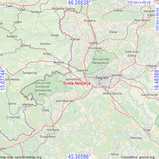
Sveta Nedjelja GPS coordinates[2]
45° 47' 53.988" North, 15° 46' 50.016" East
| Map corner | latitude | longitude |
|---|---|---|
| Upper-left | 46.28638°, | 15.07744° |
| Center: | 45.79833°, | 15.78056° |
| Lower-right: | 45.30596°, | 16.48369° |
| Map W x H: | 109×109 km | = 67.7×67.7mi |
| max Lat: | 46.52694° ⇑28.3% North |
| Sveta Nedjelja: | 45.79833° |
| min Lat: | ⇓71.7% South 42.54972° |
| min Long | Sveta Nedjelja | max Long |
| 13.52389° | 15.78056° | 19.37694° |
| W 23.9%⇐ | ⇒76.1% E |
Elevation
Elevation of Sveta Nedjelja is 131 m = 430 ft, and this is 22.3 m = 73 ft below average elevation for this country.
| Max E: |
827 m = 2713 ft | 47.6% |
| Avg. | 153.3 m = 503 ft | |
| Sveta Nedjelja | 131 m = 430 ft | |
Min E: |
-1 m = -3 ft | 52.4% |
See also: Croatia elevation on elevation.city.
Geographical zone
Sveta Nedjelja is located in North temperate zone (between Tropic of Cancer and the Arctic Circle). Distance of this North polar circle is 2308.9 km =1434.7 mi to North.| Distance of | km | miles | from Sveta Nedjelja |
|---|---|---|---|
| North Pole | 4914.8 | 3053.9 | to North |
| Arctic Circle | 2308.9 | 1434.7 | to North |
| Tropic Cancer | 2486.4 | 1545 | to South |
| Equator | 5092.3 | 3164.2 | to South |


Nearby cities:
15 places around Sveta Nedjelja: (largest is in red/bold)
• Bestovje
3 km =1.9 mi,  68°
68°
• Domaslovec
2.4 km =1.5 mi,  297°
297°
• Ivanec Bistranski
6.7 km =4.2 mi,  36°
36°
• Ježdovec
5.6 km =3.5 mi,  107°
107°
• Kerestinec
3.8 km =2.4 mi,  145°
145°
• Kladje
4 km =2.5 mi,  245°
245°
• Mala Gorica
3.5 km =2.2 mi,  176°
176°
• Mala Rakovica
5.2 km =3.2 mi, 251°
• Molvice
3.8 km =2.4 mi,  207°
207°
• Orešje
2.6 km =1.6 mi, 40°
• Rakitje
3.3 km =2.1 mi,  98°
98°
• Rakov Potok
6.8 km =4.2 mi,  169°
169°
• Samobor
4.9 km =3 mi,  276°
276°
• Velika Rakovica
6.1 km =3.8 mi,  234°
234°
• Zaprešić
6.8 km =4.2 mi,  18°
18°
Sources, notices
• [Note1] Compared only with cities in Croatia existing in our database
• [Src1] Map data: © OpenStreetMap contributors (CC-BY-SA)
• [Src2] Other city data from geonames.org with taken over terms of usage.
• [Src3] Geographical zone / Annual Mean Temperature by Robert A. Rohde @ Wikipedia
