Orešje geodata
Orešje (Zagrebačka) is a populated place; located in Croatia in Europe/Zagreb (GMT+2) time zone. With population of 1,043 people, there are 435 cities with bigger population in this country. Compared to other cities in Croatia, 73% of cities are located further ↓South; 75.4% of cities are located further →East and 51.3% of cities have higher elevation than Orešje. Note1


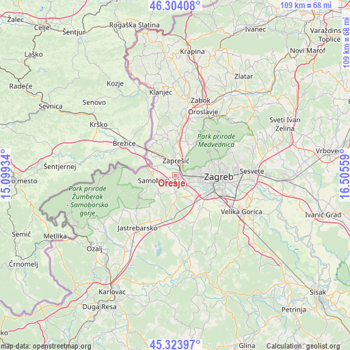
Orešje GPS coordinates[2]
45° 48' 58.248" North, 15° 48' 8.856" East
| Map corner | latitude | longitude |
|---|---|---|
| Upper-left | 46.30408°, | 15.09934° |
| Center: | 45.81618°, | 15.80246° |
| Lower-right: | 45.32397°, | 16.50559° |
| Map W x H: | 109×109 km | = 67.7×67.7mi |
| max Lat: | 46.52694° ⇑27% North |
| Orešje: | 45.81618° |
| min Lat: | ⇓73% South 42.54972° |
| min Long | Orešje | max Long |
| 13.52389° | 15.80246° | 19.37694° |
| W 24.6%⇐ | ⇒75.4% E |
Elevation
Elevation of Orešje is 125 m = 410 ft, and this is 28.3 m = 93 ft below average elevation for this country.
| Max E: |
827 m = 2713 ft | 51.3% |
| Avg. | 153.3 m = 503 ft | |
| Orešje | 125 m = 410 ft | |
Min E: |
-1 m = -3 ft | 48.7% |
See also: Croatia elevation on elevation.city.
Geographical zone
Orešje is located in North temperate zone (between Tropic of Cancer and the Arctic Circle). Distance of this North polar circle is 2306.9 km =1433.4 mi to North.| Distance of | km | miles | from Orešje |
|---|---|---|---|
| North Pole | 4912.8 | 3052.7 | to North |
| Arctic Circle | 2306.9 | 1433.4 | to North |
| Tropic Cancer | 2488.4 | 1546.2 | to South |
| Equator | 5094.3 | 3165.5 | to South |


Nearby cities:
15 places around Orešje: (largest is in red/bold)
• Bestovje
1.4 km =0.9 mi,  128°
128°
• Brdovec
6.1 km =3.8 mi,  336°
336°
• Domaslovec
3.9 km =2.4 mi,  257°
257°
• Ivanec Bistranski
4.1 km =2.5 mi,  33°
33°
• Javorje
5.7 km =3.5 mi,  328°
328°
• Ježdovec
5.2 km =3.2 mi, 134°
• Kerestinec
5.1 km =3.2 mi,  174°
174°
• Kladje
6.5 km =4 mi,  235°
235°
• Mala Gorica
5.7 km =3.5 mi,  195°
195°
• Molvice
6.3 km =3.9 mi,  213°
213°
• Rakitje
2.9 km =1.8 mi,  148°
148°
• Samobor
6.7 km =4.2 mi, 257°
• Stenjevec
6.3 km =3.9 mi,  97°
97°
• Sveta Nedjelja
2.6 km =1.6 mi,  220°
220°
• Zaprešić
4.5 km =2.8 mi,  5°
5°
Sources, notices
• [Note1] Compared only with cities in Croatia existing in our database
• [Src1] Map data: © OpenStreetMap contributors (CC-BY-SA)
• [Src2] Other city data from geonames.org with taken over terms of usage.
• [Src3] Geographical zone / Annual Mean Temperature by Robert A. Rohde @ Wikipedia
