Radoboj geodata
Radoboj (Krapinsko-Zagorska) is a seat of a second-order administrative division; located in Croatia in Europe/Zagreb (GMT+2) time zone. With population of 1,301 people, there are 342 cities with bigger population in this country. Compared to other cities in Croatia, 87.1% of cities are located further ↓South; 70.8% of cities are located further →East and 86.9% of cities have lower elevation than Radoboj. Note1


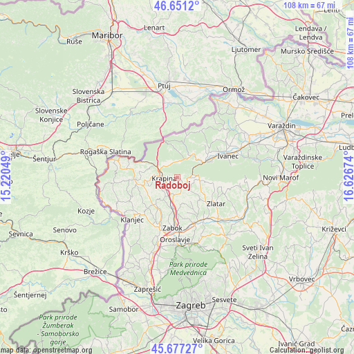
Radoboj GPS coordinates[2]
46° 9' 59.004" North, 15° 55' 24.996" East
| Map corner | latitude | longitude |
|---|---|---|
| Upper-left | 46.6512°, | 15.22049° |
| Center: | 46.16639°, | 15.92361° |
| Lower-right: | 45.67727°, | 16.62674° |
| Map W x H: | 108.3×108.3 km | = 67.3×67.3mi |
| max Lat: | 46.52694° ⇑12.9% North |
| Radoboj: | 46.16639° |
| min Lat: | ⇓87.1% South 42.54972° |
| min Long | Radoboj | max Long |
| 13.52389° | 15.92361° | 19.37694° |
| W 29.2%⇐ | ⇒70.8% E |
Elevation
Elevation of Radoboj is 257 m = 843 ft, and this is 103.7 m = 340 ft above average elevation for this country.
| Max E: |
827 m = 2713 ft | 13.1% |
| Radoboj | 257 m 843 ft | |
| Avg. | 153.3 m = 503 ft | |
Min E: |
-1 m = -3 ft | 86.9% |
See also: Croatia elevation on elevation.city.
Geographical zone
Radoboj is located in North temperate zone (between Tropic of Cancer and the Arctic Circle). Distance of this North polar circle is 2268 km =1409.3 mi to North.| Distance of | km | miles | from Radoboj |
|---|---|---|---|
| North Pole | 4873.8 | 3028.4 | to North |
| Arctic Circle | 2268 | 1409.3 | to North |
| Tropic Cancer | 2527.3 | 1570.4 | to South |
| Equator | 5133.2 | 3189.6 | to South |


Nearby cities:
15 places around Radoboj: (largest is in red/bold)
• Bednja
8.5 km =5.3 mi,  32°
32°
• Donja Pačetina
8.9 km =5.5 mi,  200°
200°
• Gornje Jesenje
4.5 km =2.8 mi,  349°
349°
• Krapina
3.5 km =2.2 mi,  259°
259°
• Krapinske Toplice
10.2 km =6.3 mi,  217°
217°
• Lepoglava
9.9 km =6.2 mi,  60°
60°
• Lobor
10.6 km =6.6 mi,  100°
100°
• Lobor
11.2 km =7 mi, 97°
• Mihovljan
5.3 km =3.3 mi,  134°
134°
• Novi Golubovec
4.5 km =2.8 mi,  81°
81°
• Petrovsko
6.4 km =4 mi,  271°
271°
• Sveti Križ Začretje
9.6 km =6 mi,  185°
185°
• Velika Ves
5 km =3.1 mi,  207°
207°
• Ðurmanec
7.2 km =4.5 mi,  297°
297°
• Škarićevo
7.3 km =4.5 mi,  231°
231°
Sources, notices
• [Note1] Compared only with cities in Croatia existing in our database
• [Src1] Map data: © OpenStreetMap contributors (CC-BY-SA)
• [Src2] Other city data from geonames.org with taken over terms of usage.
• [Src3] Geographical zone / Annual Mean Temperature by Robert A. Rohde @ Wikipedia
