Lepoglava geodata
Lepoglava (Varaždinska) is a seat of a second-order administrative division; located in Croatia in Europe/Zagreb (GMT+2) time zone. With population of 4,104 people, there are 98 cities with bigger population in this country. Compared to other cities in Croatia, 89.1% of cities are located further ↓South; 67.9% of cities are located further →East and 82.5% of cities have lower elevation than Lepoglava. Note1


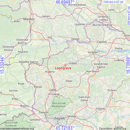
Lepoglava GPS coordinates[2]
46° 12' 38.016" North, 16° 2' 8.016" East
| Map corner | latitude | longitude |
|---|---|---|
| Upper-left | 46.69497°, | 15.33244° |
| Center: | 46.21056°, | 16.03556° |
| Lower-right: | 45.72183°, | 16.73869° |
| Map W x H: | 108.2×108.2 km | = 67.2×67.2mi |
| max Lat: | 46.52694° ⇑10.9% North |
| Lepoglava: | 46.21056° |
| min Lat: | ⇓89.1% South 42.54972° |
| min Long | Lepoglava | max Long |
| 13.52389° | 16.03556° | 19.37694° |
| W 32.1%⇐ | ⇒67.9% E |
Elevation
Elevation of Lepoglava is 220 m = 722 ft, and this is 66.7 m = 219 ft above average elevation for this country.
| Max E: |
827 m = 2713 ft | 17.5% |
| Lepoglava | 220 m 722 ft | |
| Avg. | 153.3 m = 503 ft | |
Min E: |
-1 m = -3 ft | 82.5% |
See also: Croatia elevation on elevation.city.
Geographical zone
Lepoglava is located in North temperate zone (between Tropic of Cancer and the Arctic Circle). Distance of this North polar circle is 2263 km =1406.2 mi to North.| Distance of | km | miles | from Lepoglava |
|---|---|---|---|
| North Pole | 4868.9 | 3025.4 | to North |
| Arctic Circle | 2263 | 1406.2 | to North |
| Tropic Cancer | 2532.2 | 1573.4 | to South |
| Equator | 5138.1 | 3192.7 | to South |


Nearby cities:
15 places around Lepoglava: (largest is in red/bold)
• Bedenec
4.3 km =2.7 mi,  40°
40°
• Bednja
4.6 km =2.9 mi,  298°
298°
• Gornje Jesenje
9.5 km =5.9 mi,  267°
267°
• Ivanec
6.6 km =4.1 mi,  77°
77°
• Jerovec
6.4 km =4 mi,  60°
60°
• Klenovnik
7.1 km =4.4 mi,  21°
21°
• Lobor
6.9 km =4.3 mi,  158°
158°
• Lobor
7.1 km =4.4 mi,  165°
165°
• Mihovljan
9.9 km =6.2 mi,  209°
209°
• Novi Golubovec
6 km =3.7 mi,  224°
224°
• Prigorec
7.5 km =4.7 mi,  99°
99°
• Radoboj
9.9 km =6.2 mi,  240°
240°
• Salinovec
9.8 km =6.1 mi, 81°
• Žarovnica
3.5 km =2.2 mi,  28°
28°
• Žarovnica
5 km =3.1 mi,  0°
0°
Sources, notices
• [Note1] Compared only with cities in Croatia existing in our database
• [Src1] Map data: © OpenStreetMap contributors (CC-BY-SA)
• [Src2] Other city data from geonames.org with taken over terms of usage.
• [Src3] Geographical zone / Annual Mean Temperature by Robert A. Rohde @ Wikipedia
