Lobor geodata
Lobor (Krapinsko-Zagorska) is a populated place; located in Croatia in Europe/Zagreb (GMT+2) time zone. With population of 521 people, there are 854 cities with bigger population in this country. Compared to other cities in Croatia, 86.2% of cities are located further ↓South; 67.3% of cities are located further →East and 88.3% of cities have lower elevation than Lobor. Note1


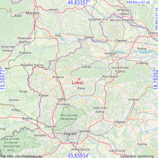
Lobor GPS coordinates[2]
46° 8' 54.996" North, 16° 3' 32.004" East
| Map corner | latitude | longitude |
|---|---|---|
| Upper-left | 46.63357°, | 15.35577° |
| Center: | 46.14861°, | 16.05889° |
| Lower-right: | 45.65934°, | 16.76202° |
| Map W x H: | 108.3×108.3 km | = 67.3×67.3mi |
| max Lat: | 46.52694° ⇑13.8% North |
| Lobor: | 46.14861° |
| min Lat: | ⇓86.2% South 42.54972° |
| min Long | Lobor | max Long |
| 13.52389° | 16.05889° | 19.37694° |
| W 32.7%⇐ | ⇒67.3% E |
Elevation
Elevation of Lobor is 271 m = 889 ft, and this is 117.7 m = 386 ft above average elevation for this country.
| Max E: |
827 m = 2713 ft | 11.7% |
| Lobor | 271 m 889 ft | |
| Avg. | 153.3 m = 503 ft | |
Min E: |
-1 m = -3 ft | 88.3% |
See also: Croatia elevation on elevation.city.
Geographical zone
Lobor is located in North temperate zone (between Tropic of Cancer and the Arctic Circle). Distance of this North polar circle is 2269.9 km =1410.5 mi to North.| Distance of | km | miles | from Lobor |
|---|---|---|---|
| North Pole | 4875.8 | 3029.7 | to North |
| Arctic Circle | 2269.9 | 1410.5 | to North |
| Tropic Cancer | 2525.3 | 1569.1 | to South |
| Equator | 5131.2 | 3188.4 | to South |


Nearby cities:
15 places around Lobor: (largest is in red/bold)
• Bedenec
10.2 km =6.3 mi,  5°
5°
• Bednja
10.8 km =6.7 mi,  327°
327°
• Ivanec
9.5 km =5.9 mi,  29°
29°
• Jerovec
10.7 km =6.6 mi,  20°
20°
• Lepoglava
7.1 km =4.4 mi,  345°
345°
• Lobor
0.8 km =0.5 mi,  55°
55°
• Mače
6.3 km =3.9 mi,  196°
196°
• Mihovljan
6.9 km =4.3 mi,  255°
255°
• Novi Golubovec
6.6 km =4.1 mi,  293°
293°
• Poznanovec
11.1 km =6.9 mi,  192°
192°
• Prigorec
8 km =5 mi,  44°
44°
• Radoboj
10.6 km =6.6 mi,  280°
280°
• Salinovec
11.5 km =7.1 mi, 43°
• Zlatar
6.1 km =3.8 mi,  171°
171°
• Žarovnica
10 km =6.2 mi,  359°
359°
Sources, notices
• [Note1] Compared only with cities in Croatia existing in our database
• [Src1] Map data: © OpenStreetMap contributors (CC-BY-SA)
• [Src2] Other city data from geonames.org with taken over terms of usage.
• [Src3] Geographical zone / Annual Mean Temperature by Robert A. Rohde @ Wikipedia
