Mihovljan geodata
Mihovljan (Krapinsko-Zagorska) is a seat of a second-order administrative division; located in Croatia in Europe/Zagreb (GMT+2) time zone. With population of 1,236 people, there are 366 cities with bigger population in this country. Compared to other cities in Croatia, 86% of cities are located further ↓South; 69.8% of cities are located further →East and 83.4% of cities have lower elevation than Mihovljan. Note1


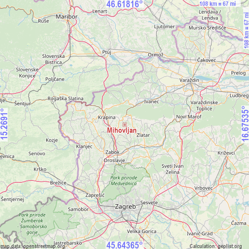
Mihovljan GPS coordinates[2]
46° 7' 59.016" North, 15° 58' 19.992" East
| Map corner | latitude | longitude |
|---|---|---|
| Upper-left | 46.61816°, | 15.2691° |
| Center: | 46.13306°, | 15.97222° |
| Lower-right: | 45.64365°, | 16.67535° |
| Map W x H: | 108.4×108.4 km | = 67.4×67.4mi |
| max Lat: | 46.52694° ⇑14% North |
| Mihovljan: | 46.13306° |
| min Lat: | ⇓86% South 42.54972° |
| min Long | Mihovljan | max Long |
| 13.52389° | 15.97222° | 19.37694° |
| W 30.2%⇐ | ⇒69.8% E |
Elevation
Elevation of Mihovljan is 227 m = 745 ft, and this is 73.7 m = 242 ft above average elevation for this country.
| Max E: |
827 m = 2713 ft | 16.6% |
| Mihovljan | 227 m 745 ft | |
| Avg. | 153.3 m = 503 ft | |
Min E: |
-1 m = -3 ft | 83.4% |
See also: Croatia elevation on elevation.city.
Geographical zone
Mihovljan is located in North temperate zone (between Tropic of Cancer and the Arctic Circle). Distance of this North polar circle is 2271.7 km =1411.6 mi to North.| Distance of | km | miles | from Mihovljan |
|---|---|---|---|
| North Pole | 4877.5 | 3030.7 | to North |
| Arctic Circle | 2271.7 | 1411.6 | to North |
| Tropic Cancer | 2523.6 | 1568.1 | to South |
| Equator | 5129.5 | 3187.3 | to South |


Nearby cities:
15 places around Mihovljan: (largest is in red/bold)
• Bedekovčina
10.4 km =6.5 mi,  169°
169°
• Donja Pačetina
8.3 km =5.2 mi,  236°
236°
• Gornje Jesenje
9.4 km =5.8 mi,  330°
330°
• Krapina
7.8 km =4.8 mi,  293°
293°
• Lepoglava
9.9 km =6.2 mi,  29°
29°
• Lobor
6.9 km =4.3 mi,  75°
75°
• Lobor
7.7 km =4.8 mi,  73°
73°
• Mače
6.5 km =4 mi,  131°
131°
• Novi Golubovec
4.4 km =2.7 mi,  8°
8°
• Poznanovec
10.1 km =6.3 mi,  154°
154°
• Radoboj
5.3 km =3.3 mi,  314°
314°
• Sveti Križ Začretje
7.5 km =4.7 mi,  219°
219°
• Velika Ves
6.2 km =3.9 mi,  263°
263°
• Zlatar
8.7 km =5.4 mi,  119°
119°
• Škarićevo
9.5 km =5.9 mi,  265°
265°
Sources, notices
• [Note1] Compared only with cities in Croatia existing in our database
• [Src1] Map data: © OpenStreetMap contributors (CC-BY-SA)
• [Src2] Other city data from geonames.org with taken over terms of usage.
• [Src3] Geographical zone / Annual Mean Temperature by Robert A. Rohde @ Wikipedia
