Privlaka geodata
Privlaka (Vukovar-Sirmium) is a seat of a second-order administrative division; located in Croatia in Europe/Zagreb (GMT+2) time zone. With population of 3,794 people, there are 104 cities with bigger population in this country. Compared to other cities in Croatia, 67.1% of cities are located further ↑North; 96.3% of cities are located further ←West and 83.8% of cities have higher elevation than Privlaka. Note1


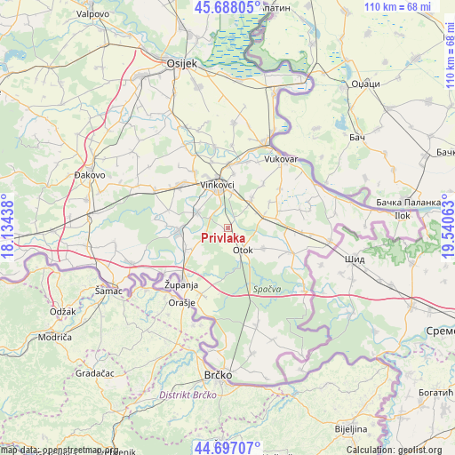
Privlaka GPS coordinates[2]
45° 11' 40.992" North, 18° 50' 15" East
| Map corner | latitude | longitude |
|---|---|---|
| Upper-left | 45.68805°, | 18.13438° |
| Center: | 45.19472°, | 18.8375° |
| Lower-right: | 44.69707°, | 19.54063° |
| Map W x H: | 110.2×110.2 km | = 68.5×68.5mi |
| max Lat: | 46.52694° ⇑67.1% North |
| Privlaka: | 45.19472° |
| min Lat: | ⇓32.9% South 42.54972° |
| min Long | Privlaka | max Long |
| 13.52389° | 18.8375° | 19.37694° |
| W 96.3%⇐ | ⇒3.7% E |
Elevation
Elevation of Privlaka is 81 m = 266 ft, and this is 72.3 m = 237 ft below average elevation for this country.
| Max E: |
827 m = 2713 ft | 83.8% |
| Avg. | 153.3 m = 503 ft | |
| Privlaka | 81 m = 266 ft | |
Min E: |
-1 m = -3 ft | 16.2% |
See also: Croatia elevation on elevation.city.
Geographical zone
Privlaka is located in North temperate zone (between Tropic of Cancer and the Arctic Circle). Distance of this North polar circle is 2376 km =1476.4 mi to North.| Distance of | km | miles | from Privlaka |
|---|---|---|---|
| North Pole | 4981.9 | 3095.6 | to North |
| Arctic Circle | 2376 | 1476.4 | to North |
| Tropic Cancer | 2419.3 | 1503.3 | to South |
| Equator | 5025.2 | 3122.5 | to South |


Nearby cities:
15 places around Privlaka: (largest is in red/bold)
• Andrijaševci
8.5 km =5.3 mi,  293°
293°
• Cerić
13.1 km =8.1 mi,  6°
6°
• Cerna
11.7 km =7.3 mi,  263°
263°
• Gradište
11.5 km =7.1 mi,  243°
243°
• Komletinci
10.1 km =6.3 mi,  119°
119°
• Mirkovci
8.4 km =5.2 mi, 7°
• Novi Jankovci
6.8 km =4.2 mi,  42°
42°
• Orolik
11.8 km =7.3 mi,  78°
78°
• Otok
6.5 km =4 mi,  145°
145°
• Petrovcy
13.4 km =8.3 mi, 38°
• Rokovci
8.4 km =5.2 mi,  298°
298°
• Slakovci
9.4 km =5.8 mi,  69°
69°
• Srijemske Laze
8.4 km =5.2 mi,  61°
61°
• Stari Jankovci
9.6 km =6 mi, 38°
• Vinkovci
10.7 km =6.6 mi,  346°
346°
Sources, notices
• [Note1] Compared only with cities in Croatia existing in our database
• [Src1] Map data: © OpenStreetMap contributors (CC-BY-SA)
• [Src2] Other city data from geonames.org with taken over terms of usage.
• [Src3] Geographical zone / Annual Mean Temperature by Robert A. Rohde @ Wikipedia
